


RESEARCH PAPER
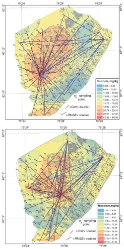
The optimization of environmental soil monitoring based on representative selection of a training subset for an artificial neural network is an unresolved problem in the tasks of interpolation of the distribution of metals in the topsoil. The soil survey data, often used as input for artificial neural network modeling, are datasets at irregular points. Usually, the division of the input data into training and test subsets is carried out randomly in a ratio of 70% to 30% points, respectively. The question of the individual and collective representativeness of local sampling points on the element content in the soil in a given area for a training subset remains beyond the scope of interpolation problems. In this work, the representativeness of the sampling points plays a crucial role in reducing the ANN error and enhancing the correlation between the results of model calculations on the test subset and natural measurements when the points are part of the training subset. When evaluating the pairwise representativeness, we found two types of effects: synergy and anti-synergy. The synergy was achieved with an increase in model accuracy when the pair entered the training subset. The anti-synergy manifested in a decrease informativeness of the point pair for modeling. The various sampling locations have different information and unequal meaning for feature interpolation. The scale-free network structures were found to have pairwise representativeness by RMSE.
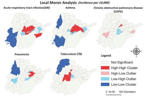
Respiratory diseases constitute a significant burden of morbidity and mortality in developing nations such as Pakistan. This study aims to analyze five prevalent respiratory ailments - acute respiratory infections (ARI), tuberculosis (TB), pneumonia, asthma, and chronic obstructive pulmonary diseases (COPD) - within South Punjab, Pakistan. Utilizing the tehsil level (the administrative sub unit of district), case data spanning five years (2016-2020) were collected from 1,487 government health centers across the study area. Spatial analysis techniques including Local Moran’s I and Getis Ord Gi* statistics were employed to identify clusters and outliers. The results revealed spatial heterogeneity in respiratory disease prevalence, delineating both high-intensity (hotspots) and low-intensity (cold spots) clusters across the region. Specifically, ARI hotspots were observed in northeastern and central regions, asthma hotspots in central and north-central areas, COPD hotspot areas in the north and northeast, pneumonia hotspots in the central region, and TB hotspots predominantly in the central region. These findings offer critical insights for targeted public health interventions, facilitating resource allocation for disease prevention and control efforts. Additionally, this study presents recommendations addressing local environmental and socio-economic factors to mitigate respiratory disease incidence through administrative environmental management and community engagement strategies.
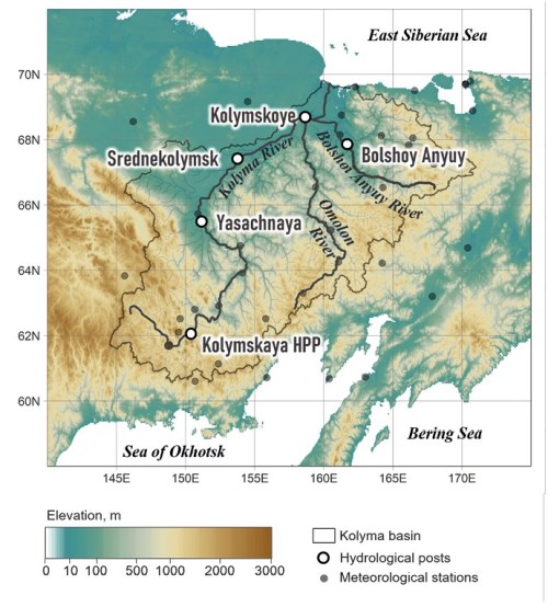
Using the physically-based model of runoff formation ECOMAG (ECOlogical Model for Applied Geophysics), the response of the Kolyma River’s water regime to ongoing and projected climate changes has been investigated. To operate the ECOMAG model, which calculates daily water discharges for control sections, information was gathered on the characteristics of the land surface and watershed relief, as well as archives of daily observations from meteorological stations within the basin. The calibration and validation of the model, performed for two sections on the Kolyma River and two sections on its tributaries – the Bolshoy Anyuy and Yasachnaya rivers – demonstrated strong agreement between the modelled and observed water discharges for the Kolyma River. Moreover, the analysis of observed water discharges and those calculated by the ECOMAG model reveals similar changes in the water regime that occurred from 1979 to 2020, such as an increase in annual and summer-autumn runoff, and a decrease in the duration of the winter low-flow period. To assess potential changes in the Kolyma River’s runoff in the 21st century, numerical experiments were conducted using the ECOMAG hydrological model and an ensemble of four global climate models. Calculations were performed for the periods 2020–2039, 2040–2059, 2060–2079, and 2080–2099 for four different Representative Concentration Pathway (RCP) scenarios. Anomalies in annual runoff, peak water discharges, flood volumes, winter low-flow periods, and summer-autumn periods were considered. Under all scenarios, the calculations indicate an increase in the annual and summer-autumn runoff of the Kolyma River.
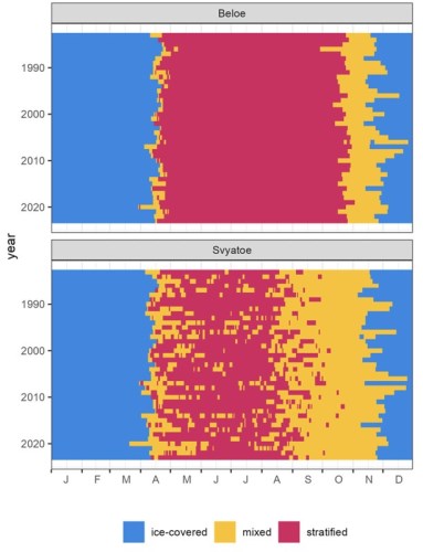
The one-dimensional lake model GLM was used to simulate the ice and stratification dynamics of two small lakes within Moscow City, Russia – lakes Beloe and Svyatoe of the Kosino Lake group. The model was calibrated on observation data from 2021–2023, and the significant trends of the lakes’ thermal and mixing regime were calculated based on the model run for the period of 1983–2023. Some of the most distinct changes are associated with ice phenology, as both lakes lose ice cover at 4.4–5.0 days/decade. The length of the stratified period does not significantly change, but the stability of stratification in dimictic Lake Beloe is increasing. Both lakes have experienced an increase in mean surface water temperature over the year between 0.22–0.26 °C/decade, which is two times lower than the observed trend in the local air temperature. In polymictic Lake Svyatoe, bottom water temperature also increases at a maximum of 0.65 °C/decade. The fastest changes in ice phenology, water temperature and stratification occurred before 2013, while in the last decade most parameters have stabilized, despite the growing intensity of climate warming. This might demonstrate how the lakes are compensating for some of the climate signal.
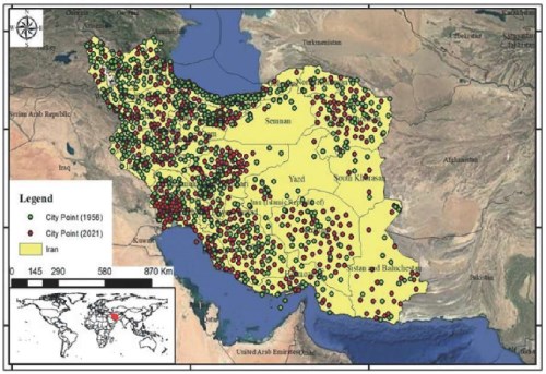
The main goal of this research study is to analyze the urban system of Iran during the years 1956 to 2021 to propose a new model. This is done by examining the primate city index of the urban settlement system based on previous models. The study employs a descriptive-analytical approach. Initially, it investigates the population trends and the number of cities in Iran over the specified period, comparing the growth rates of the total population and the urban population to assess changes in population distribution across the country. Additionally, spatial analysis of population distribution is conducted using Hot Spot Analysis and Directional Distribution methods. This article evaluates the advantages and disadvantages of various primate city indices, ultimately leading to the formulation of a new index for measuring the degree of urban primacy. The findings reveal that the percentage of the urban population in Iran surged from 31.41% in 1956 to 75.99% in 2021. According to the Mousavi primate city index, urban primacy in Iran exhibited an upward trend from 1956 to 1986, followed by a decline from 1986 to 1996. However, this trend reversed upwards in 2016, attributed to the rising number of cities and migration to newly established urban areas due to drought and relative stagnation in agriculture. The rank-size pattern further validates the outcomes of the new index.
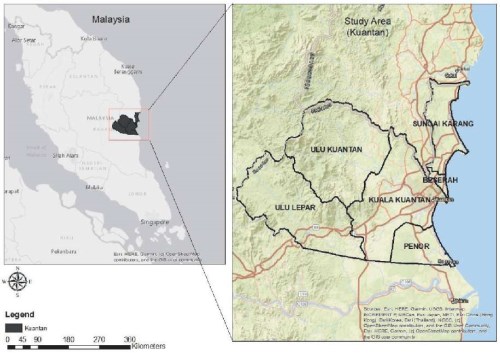
Dengue fever (DF) presents a significant public health challenge, particularly in tropical regions like Kuantan, Malaysia. This study utilizes Geographic Information System (GIS) technology to analyze spatial and temporal patterns of DF cases from 2011 to 2020. The aim is to understand geographical distribution, identify high-density areas, and discern temporal trends to guide targeted interventions. Kuantan, a rapidly urbanizing city with a notable DF incidence, serves as the study area. Leveraging a decade of Ministry of Health data encompassing 11,330 confirmed cases, ArcGIS 10.6 software maps disease distribution and identifies high-density clusters. Statistical analyses, including Kernel Density Estimation (KDE) and Standard Deviational Ellipses (SDE), reveal directional spread with Kuala Kuantan as the epicenter. Collaboration with vector control units validates high-density areas, linking environmental conditions and infrastructure to DF incidence. Demographic and socioeconomic variables, urbanization, and transportation connections are identified as influential factors. The study underscores the importance of collaborative data sharing and validates GIS-based approaches for targeted interventions. Integration into an early warning system is proposed, enhancing public health strategies in Kuantan and similar regions. Overall, this research contributes to understanding DF transmission dynamics and offers proactive frameworks for mitigating its impact through advanced technologies and collaborative efforts.
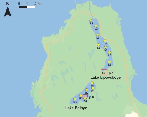
The increased number of extreme marine events is one of the most serious hazards to coastal areas around the world. The study of the impacts of marine events on coastal lakes has enabled us to gain important insights into the coastal ecosystem’s response to these events. On the Baltic Sea southeast coast as a result of studying Lake Lipovskoye and Lake Beloye on the Kurgalsky Peninsula obtained data on hydrology and hydrochemistry of the lakes, structure of lakes’sediments, the distribution of macrophytes and features of the vegetation reflection in the lakes’surface sediments based on pollen data. Bathymetric maps of lakes and their watersheds were constructed. Our complex studies confirmed the lakes’ uniqueness. According to hydrochemical data, Lake Lipovskoye has mesotrophic status and is classified as brackish water, whereas Lake Beloye is oligotrophic and freshwater. It was found that the lakes are characterized by small values of specific catchments – 10.3 for Lake Lipovskoye and 2.7 for Lake Beloye. Subrecent pollen spectra of lake surface samples quite adequately reflect modern aquatic vegetation, especially the communities of submerged hydrophytes in Lake Lipovskoye and floating hydrophytes in both lakes. Potamogeton (P. pectinatus L., P. perfoliatus L.) and Myriophyllum sp. are dominants in the pollen spectra and modern aquatic plant communities in the lakes. Over a short-term period, there are substantive differences in the species composition and dynamics of macrophyte pollen for both lakes. The study of lake sediments found a link between the Holocene sedimentation in Lipovskoye and Beloye lakes and the Baltic’s transgressive and regressive stages (Ancylus, Littorina, and Baltic Ice Lake stages).
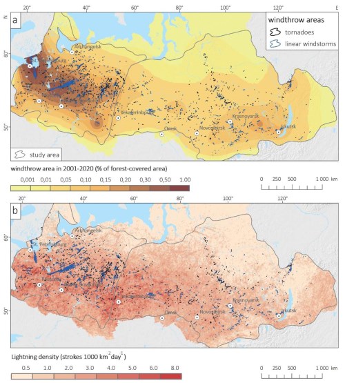
Windthrow is one of the major causes of forest loss in most forest types, depending on the frequency and intensity of severe winds and forest vulnerability. This study focuses on analyzing of the association of the spatio-temporal distribution of windthrow with the atmospheric convective parameters and lightning activity in the Russian forest zone for the period 2001-2020. The windthrow data include 1816 events that are associated with tornadoes and non-tornadic convective windstorms and are obtained from the previously developed satellite-derived database. Convective parameters are calculated based on the ERA5 reanalysis, while the Worldwide Lightning Location Network (WWLLN) is used for lightning data. It is found that both the spatial distribution and the interannual variability of windthrow events are significantly correlated with the corresponding variability of convective parameters, especially with the significant tornado parameter (STP), both in the European Russia (ER) and in Siberia. The spatial correlation between windthrow events and lightning density is also significant, with a stronger relationship in the ER than in Siberia. For inter-annual variability, it is also found a strong relationship between the number of days with supercritical STP values and the total windthrow area per season. Our results highlight STP and lightning density as informative predictors that can be used as characteristics of windthrow in the Russian forests and for further estimation of associated risks, which is important for sustainable forest management.
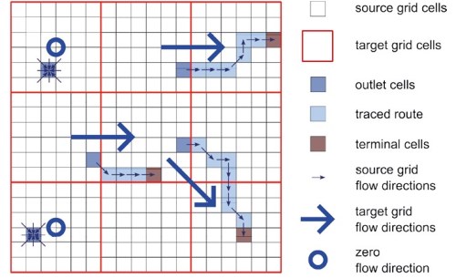
Modern Earth system models and global hydrological models require input data in the form of flow direction grids (rasters) with a relatively low resolution. Typical resolution for these models is about 0.5–1°. At high resolution, up to 1 km cell size, flow direction grids are usually generated from digital elevation models (DEMs), but for coarse-resolution grids, more specialized approaches need to be used. In this paper we review upscaling methods for flow direction grids, including grid-based flow tracing, catchment area aggregation and vector network processing. We also indicate methods that have been used to create publicly available datasets in global coverage (DRT and IHU), and provide links to these datasets. The paper also considers methods for estimating the result of flow direction generation on coarse-resolution grids, as well as the results of applying these estimates to existing methods. It is shown that the task of estimating the result requires further development, including the development of new estimation methods and comparative comparison of the most modern upscaling approaches.
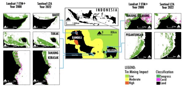
Seagrass meadows are important blue carbon ecosystems. They are threatened by various anthropogenic activities, including mining, which affect the ecological health. This study investigates the impact of sea-based tin mining activities on the carbon storage capabilities of seagrass meadows in Bangka Belitung, Indonesia. The objective of the study is to quantify carbon stocks and sequestrations in these ecosystems and understand how mining influences these critical natural resources. The research was conducted at various seagrass sites with different levels of mining impacts. Carbon stocks and sequestration were measured using the Loss on Ignition method, and net primary productivity was calculated. Remote sensing data from Landsat 7 and Sentinel-2A satellites were used to monitor changes in seagrass cover over time. Sedimentation rates and total suspended solids were measured to assess environmental impacts. Statistical analysis, including correlation and cluster analysis, examined the relationship between mining activity and seagrass health. The findings indicate a significant decrease in seagrass coverage and carbon storage in areas with high levels of tin mining. Specifically, areas with intensive mining showed higher rates of sedimentation and total suspended solids, which correlated with reduced seagrass biomass and carbon sequestration. This decrease compromises the ecological role of seagrass meadows as effective carbon sinks, highlighting the destructive impact of mining activities on these ecosystems.
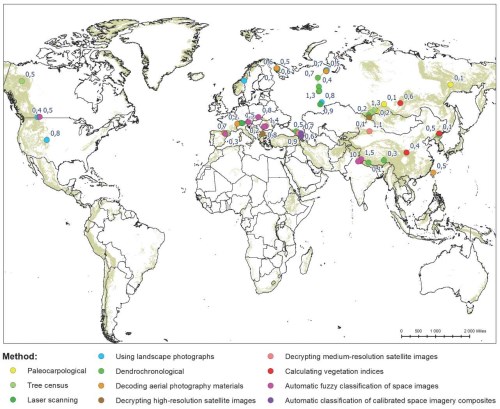
This paper provides a review and comparison of the methods for assessing trends in the dynamics of alpine treeline (ATL) in high mountains are presented in. The methods analyzed are contemporary, traditionally used (dendrochronological and paleocarpological methods, retrospective analysis of historical photographs and geodetic surveying, and multi-temporal aerial photography), and innovative ones developed in recent decades (semi-automatic and automatic methods of interpretation of high- and medium-resolution space imagery and methods of space imagery interpretation using different techniques, such as classification, segmentation, vegetation index analysis, and machine learning algorithms). Different interpretations of the concept of 'alpine treeline', which is currently established in geobotany and landscape sciences, are discussed. The attention to ATL dynamics is caused by global climate change's widespread forest increase and the decline in high mountain pastures. The ATL phenomenon's geographic map is condensed and displayed. There is an overview of the experience with different methods in varying mountain regions around the world. Each method is described in terms of its spatial scale, coverage, advantages, labor intensity, complexity, and limitations. It is shown that The effectiveness of the methods mainly depends on two key factors: the size of the area being studied and the time period over which changes are observed. The problem that still limits the use of remote sensing data is the contradiction between the accuracy of measurements and the coverage of the territories involved. To solve this problem, we suggest using a mix of methods that involve automatically classifying medium-resolution space images. This will be done by training on data collected from both fieldwork and lab experiments using different techniques.
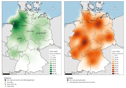
This study highlights the importance of understanding the geographical context of innovation processes in industries driven by tacit knowledge, with German wind energy as its object of investigation. The subject of the research is the spatial organization of innovation processes in the wind energy sector, focusing on the co-location of inventors, production facilities, and installed capacities, particularly among locally embedded enterprises. The aim of this research is to characterize the geography of innovation in the German wind energy sector by examining the correlation between innovation departments and installed capacities, the degree of company embeddedness, and the industry’s stage of development. The novelty lies in the application of a spatial analysis framework combined with network theory to explore how proximity and embeddedness shape the innovation cycle. The study developed a methodology to quantitatively assess the co-location of company branches and installed capacities over time using influence zones. Findings reveal a strong link between the locations of knowledge-generation sites and installed capacities, especially for embedded enterprises, where co-location coefficients within a 50-km radius range from 1.9 to 2.5. This correlation strengthens over time, particularly from 2000–2009 to 2010–2019. Foreign enterprises show high co-location coefficients for manufacturing sites but not for innovation departments. Further research is needed to explore the interplay of tacit and formalized knowledge in increasingly complex innovation processes and to determine causality in co-location patterns between innovators and installed capacities.
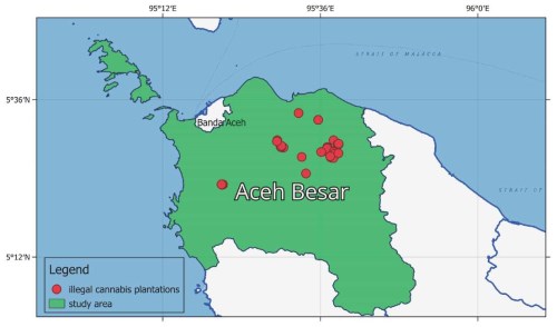
Remote sensing technology and machine learning classifiers can be utilized to develop smart detection systems for illicit crops such as Cannabis sativa L. Machine learning algorithms for classifying medium-resolution optical satellite data can be compared to identify the best model for enhancing law enforcement’s detection of illicit crops efficiently and accurately. Remote sensing-based smart detection systems have been developed in South America and Central Asia; however, these methods cannot be used effectively for Indonesia due to high cloud coverage, geographical differences, and the smaller area of Cannabis sativa L. plantations. This research developed an agile methodology that employs backpropagation neural networks to analyze the statistical growth phenology of cannabis derived from multitemporal medium-resolution remote sensing data. Using datasets derived from Indonesian law enforcement eradication records, the method achieved 94% accuracy and a kappa coefficient of 0.9. Further, plant growth phenology based on vegetation index values from multitemporal data was used to assess the condition of identified cannabis plantations.
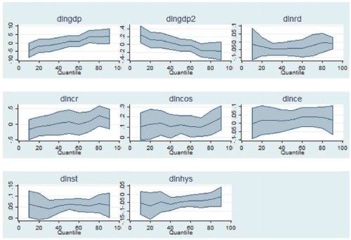
The problem of studying carbon footprint factors is one of the key ones for understanding the relationship between socio-economic development and atmospheric pollution. We employ a panel quantile regression approach to reveal the impact of the energy sector (namely, coal-based electricity and hydropower generation), manufacturing (steel and cement production), and agriculture (cropland area change) on CO2 emissions in 16 Eastern European and 4 Central Asian countries for the period from 2000 to 2020. We provide evidence for a U-shaped environmental Kuznets curve for countries with a lower carbon footprint, while the countries with the highest emissions are found to have an inverted U-shaped relationship between them and GDP per capita. The relationship between electricity production from coal and emissions is positive and significant at all quantiles (except the 30th quantile), and for hydropower, it is negative and significant from the 20th to 70th quantile: a 1% increase in generation leads to CO2 emissions increase by 0.08-0.20% and a decrease by 0.04-0.07%, respectively. Crude steel production positively influences emissions (from the 10th to 80th quantile levels): a 1% increase in the output of steel products results in carbon emissions increase by 0.05-0.07%. The relationship between cropland expansion and emissions is positive from the 40th quantile, but the coefficient shows high significance only at the 80th quantile. These findings allow us to conclude that CO2 emissions reduction in Eastern European and Central Asian countries could be achieved by the replacement of coal in the electricity generation structure by renewables (including hydropower), the introduction of sustainable land use practices to preserve carbon sinks, and technological modernization of crude steel production.

ISSN 2542-1565 (Online)


