


Scientific and applied peer-reviewed journal
Aim of the journal “GEOGRAPHY, ENVIRONMENT, SUSTAINABILITY” is to illuminate geographical and related interdisciplinary scientific fields, new approaches and methods along with a wide range of their practical applications. This goal covers a broad spectrum of scientific research areas and also considers contemporary and widely used research methods, such as geoinformatics, cartography, remote sensing, geophysics, geochemistry, etc.
In the areas of “GEOGRAPHY, ENVIRONMENT, and SUSTAINABILITY” a new challenge to structure accumulated knowledge, to describe inner relations, and to form spheres of influence between different disciplines has emerged. The scope of the GES is to publish original and innovative papers that will substantially improve, in a theoretical, conceptual or empirical way the quality of research, learning, teaching and applying geography, as well as in promoting the significance of geography as a discipline.
The main sections of the journal are the theory of geography and ecology, the theory of sustainable development, use of natural resources, natural resources assessment, global and regional changes of environment and climate, social-economical geography, ecological regional planning, sustainable regional development, applied aspects of geography and ecology, geoinformatics and ecological cartography, ecological problems of oil and gas sector, nature conservations, health and environment, and education for sustainable development.
Articles are freely available to both subscribers and the wider public with permitted reuse. The printed version contains color figures . Color reproduction in print is free of charge of all accepted articles. Journal publishes 4 issues per year, each issue 120–150 pages long. Manuscripts are submitted and peer-reviewed in an on-line mode.
Current issue
RESEARCH PAPER
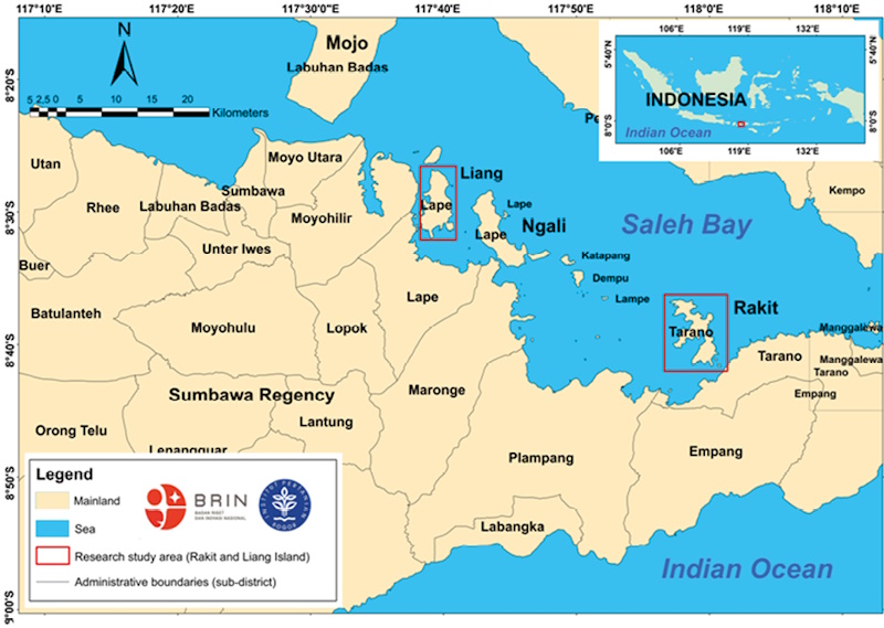
Coral reef ecosystems are vital for marine biodiversity, coastal protection, and local livelihoods, yet environmental and anthropogenic stressors increasingly threaten them. Accurate and timely mapping of these habitats is essential for effective management and conservation planning. This study aims to evaluate and compare the spatial distribution and extent of coral reef habitats around Liang and Rakit Islands, as well as to assess the classification accuracy of Sentinel-2 Level-2A and the SPOT-7 satellite imagery for the years 2016 and 2021. Both datasets were pre-processed through atmospheric and sun-glint corrections, with SPOT-7 imagery further enhanced by water column correction using the Lyzenga algorithm. Supervised classification in ENVI was used to map four shallow-water habitat classes (coral reef, seagrass, sand, and rubble), and classification accuracy was assessed using confusion matrices to compute Producer Accuracy (PA), User Accuracy (UA), and Overall Accuracy (OA). Across both islands, coral reef and seagrass each occupied roughly one quarter of the mapped shallow-water area, while sand and rubble together accounted for about half of the area, indicating a heterogeneous mosaic of fringing reefs and seagrass meadows interspersed with sandy and rubbly substrates. Maps derived from SPOT-7 imagery produced higher overall accuracies (84% for Liang and 82% for Rakit) than those derived from Sentinel-2A imagery (76% and 70%, respectively). SPOT-7-based classifications consistently delineated larger and more detailed extents of coral reef and seagrass habitats, demonstrating the value of higher-resolution imagery for representing fine-scale features in optically complex coastal environments, whereas Sentinel-2A imagery was more suitable for broad-scale habitat discrimination but tended to underestimate narrow or fragmented patches.
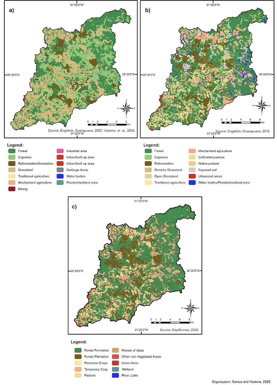
Changes in land use in Brazil, particularly agricultural expansion, have significant impacts on ecosystems and their associated services. This study aimed to evaluate the temporal and spatial dynamics of ecosystem services (ES) in the Pedras River basin (PRB), the main water supply for Guarapuava, southern Brazil, between 2002, 2018 and 2023. The analysis was based on the Ecosystem Services Identification Matrix, integrating land use and land cover (LULC) maps and field observations of environmental and socioeconomic characteristics in the area. This approach allowed the classification and assessment of the potential supply of provisioning, regulating, and cultural ES in the basin. The findings between 2002 and 2018 revealed a general decline in most regulating and cultural services, with notable reductions in genetic resources, local climate regulation, air quality regulation services, and medicinal resources. Conversely, provisioning services related to food provision, energy provision, and soil quality regulation showed increases. Between 2018 and 2023, food provision, water quality regulation, soil quality, and pollination declined, along with decreases in cultural services. In contrast, the increase occurred in water supply, raw materials, genetic resources, ornamental resources (18.16%), and air quality and climate regulation services. Agricultural expansion resulted in a trade-off, increasing food provision while simultaneously degrading other ES. The study emphasizes that sustainable land management is necessary to preserve ecosystem functions and services, thereby preventing the degradation of their potential.
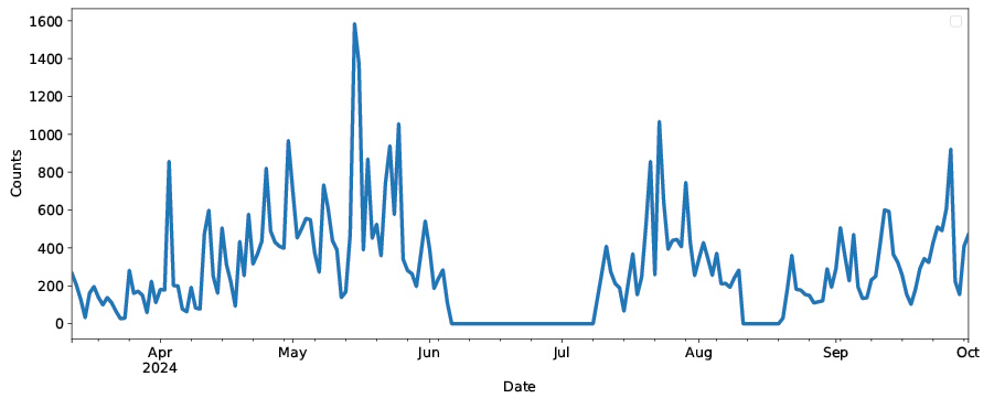
An automatic bioaerosol classification system is an attractive alternative to the standard visual identification and counting of pollen in the standard volumetric method of aerobiological monitoring. While various physical principles can be used for automatic measurement of the parameters of particles present in the air, the key problem becomes the development of a classification model based on these data. In particular, practical application of the models becomes challenging due to the large variability of particles present in real air compared to laboratory experiments in which models are usually trained. Instead of training the model on data obtained in laboratory conditions, we applied a clustering algorithm to fluorescence spectra collected during daily measurements in the 2024 season with the Rapid-E+ automatic detector installed at the monitoring station at Moscow State University. Comparison of the temporal distribution of particles in each cluster with the seasonal dynamics of eleven pollen types obtained from standard aerobiological monitoring with a volumetric trap at the same station at Moscow State University shows that some clusters (i.e., fluorescence spectra of specific shape and amplitude) demonstrate temporal patterns similar to pollen seasons. However, the fluorescence spectra alone are not sufficient for differentiation of individual pollen types, and they can only provide detection of larger groups of bioaerosols. Interestingly, the detected larger groups show more diverse seasonal patterns than those observed by volumetric monitoring at the station at Moscow State University. This result demonstrates that automatic detectors can provide more useful information on the content and seasonal distribution of bioaerosols compared to standard volumetric methods.
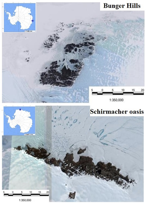
Soils of ice-free regions (oases) in East Antarctica have been rarely investigated via the prism of combined detailed biological and chemical methods. The main purpose of this work is to assess the influence of environmental factors, including microrelief and local features of the accumulation of biogenic material on the mineralization and humification of the organic matter in topsoils from Bunger Hills and Schirmacher Oasis. We used multiple techniques to analyze soil basal respiration and mineralization rates, extract humic acids, and investigate their molecular structure by ¹³C-NMR spectroscopy.
The results reveal that soil formed under moss cushions exhibits the highest levels of organic carbon (up to 2.43%), alongside elevated basal respiration rates, which reached up to 2.979±0.015 mg g −1 day−1in moist conditions. Soil pH ranged from slightly acidic to alkaline, influenced by salt accumulation, which adversely affects plant communities and limits biomass production. Using 13C-NMR spectroscopy, although in a limited number of samples, we identified a predominance of aliphatic structures in humic acids with carboxylic functional groups, indicating significant vegetation influence on organic matter complexity. The sp²/sp³ carbon ratios (0.724 for Bunger Hills and 0.408 for Schirmacher Oasis) indicate a balance between potentially decomposable aliphatic and stable aromatic structures. Mineralization rates were significantly higher in soils with greater moisture retention, with cumulative CO2 release reaching up to 150 mg CO2/kg-1 soil day¯¹ over a 30-day period. Overall, our work revealed complex relationships between the environmental conditions and soil characteristics that significantly influence biological activity, carbon storage, and organic matter structure.
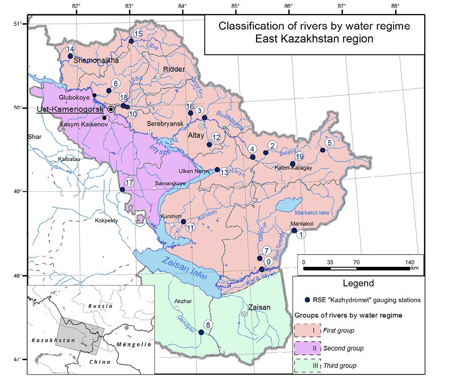
This study addresses flood estimation challenges in the Upper Irtysh River basin through comprehensive stochastic hydrological analysis. We evaluate the adequacy of various engineering methods for calculating peak discharges, with each computational approach based on probabilistic models combining: (1) theoretical probability distributions and (2) parameter estimation techniques for limited observational data. Our methodology employs an extensive range of three-parameter probability laws and frequency curve parameterization methods.
The research protocol involved: (i) rigorous stationarity testing of maximum annual discharge time series (for the period 1951-2019), and (ii) development of probabilistic frequency curves. Since conventional stochastic modelling requires stationary series, we developed methodological tools for detecting non-stationarity (particularly linear trends) and adjusting affected series through statistical normalization.
Key findings reveal that a part of studied rivers exhibit statistically significant (p<0.05) non-stationarity in annual peak flows observed as a linear trend. For such rivers, the time series were adjusted to stationary conditions. For all time-series - including the adjusted datasets - we constructed the complete set of considered probability models. From these, optimal models were selected representing different computational approaches: (1) the standard framework recommended by current regulatory documents, and (2) alternative schemes derived through comprehensive synthesis of published research.
Through application of multiple model quality criteria, it has been established that alternative computational schemes yield evidently better results compared to the standard methodology. The analysis further demonstrates that current non-stationarity in time series does not yet substantially affect the magnitude of the most critical design parameter - the 1% exceedance probability discharge. Future regional research should focus on: (1) identifying causes of non-stationarity in annual peak flow series, and (2) developing optimized computational frameworks for non-stationary conditions
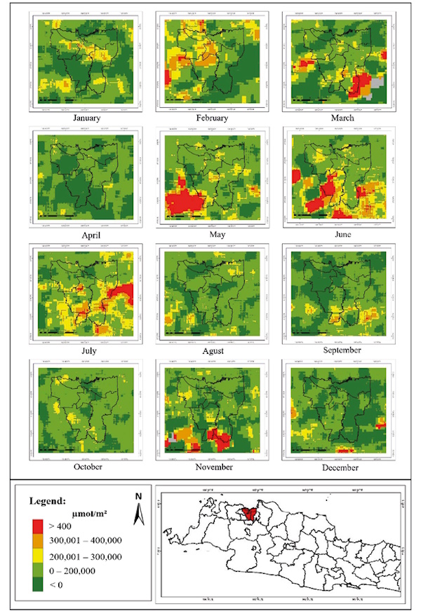
In the last few decades, rapid industrial growth and increasing urban traffic density have caused air quality problems, including in Jakarta. One indicator of air pollution is acid rain. Acid rain occurs due to pollutants in the form of SO2 and NO2 reacting with water (H2O). The impact of acid rain, among other things, can damage soil fertility, affect the quality of human life, and damage objects and infrastructure. This research aims to analyze the distribution of SO2 and NO2 spatially and temporally and create a rainwater acidity model based on the distribution of SO2 and NO2 in Jakarta. The distribution of SO2 and NO2 was obtained using remote sensing techniques using Sentinel 5P Satellite imagery. Processing is carried out using GEE. From the results of the bivariate analysis, it is known that the spatial distribution of SO2 is influenced by rainfall and is not influenced by wind speed. Meanwhile, the distribution of NO2 is significantly influenced by rainfall and wind speed. Temporally, the distribution of SO2 in 2023 has the highest value in June, and the distribution of NO2 has the highest value in August. The prediction model for rainwater acidity levels was obtained based on the distribution of SO2 and NO2 in 2023 in Jakarta. The results of multiple linear regression show a correlation between rainwater acidity and the distribution of SO2 and NO2. The correlation coefficient is (-) 0.7305, which means the correlation is in the strong category. The negative correlation explains that the higher the levels of SO2 and NO2, the more acidic the rainwater will be. A value of 13% was obtained in the MAPE calculation, which means the prediction model is included in the good category and can be used to predict rainwater acidity in Jakarta.
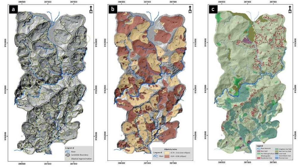
This study investigates the effects of landslide processes on land morphology and their management strategies. Land use types determine the size and morphology of the landslide, which is critical for assessment and planning. LiDAR imaging helps to locate the various features of a landslide and human intervention. The research measures the ellipticity of landslides for a 3.2 km2 area using LiDAR-derived data and ellipse numerical modeling. Landslide boundaries were delineated through automated and manual techniques, considering topographical index, visual interpretation, and expert knowledge. Convex hulls were used to approximate landslide shapes, which were then used to calculate the various ellipticity indices (eL). Bare land, mixed gardens, rain-fed rice fields, and intermittent rivers have a higher eL. Local roads, houses, and irrigated rice fields indicated receding eL values due to the increased level of land management. Changes in eL are affected by the intensity of land use and disturbances related to the wetting of landslide slip areas. Higher ellipticity indicates dynamics in the landslide activity. Therefore, land use planning should be performed considering both natural and non-natural elements in the area.
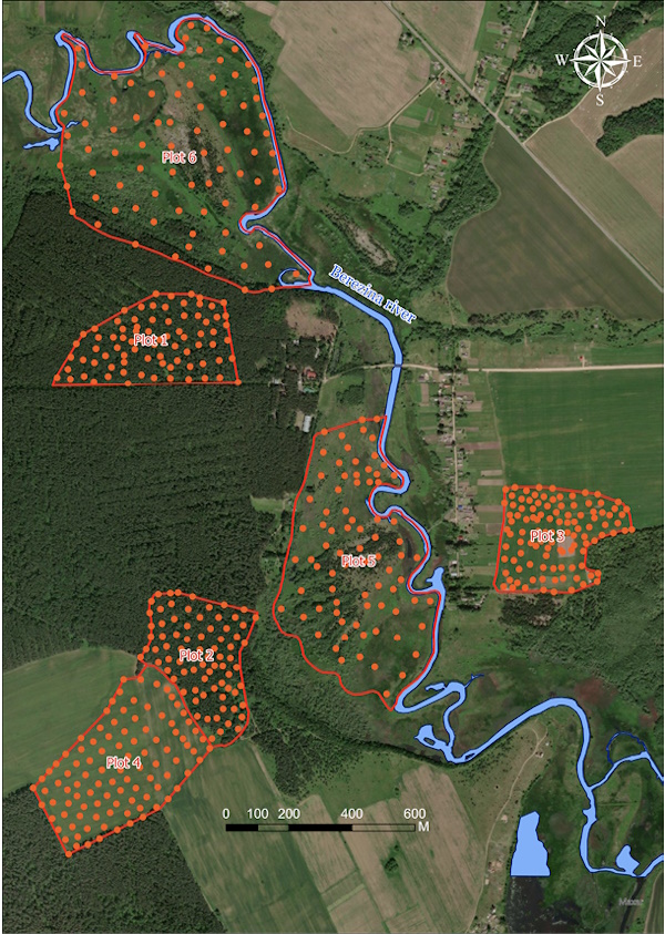
This article investigates the regularities of the spatial distribution of soil acidity on a detailed scale. А description of the soil cover and the rationale for selecting key areas within forest, arable, and meadow lands in the Berezina River valley (Belarus) are provided. A universal scheme of geostatistical diagnostics of soil cover properties is proposed, describing theoretical aspects of geostatistics, which can be applied to solve soil-geographical problems in various specialized contexts. Variogram analysis was employed to ascertain the distances at which similar soil-geochemical processes occur within the studied landscapes. In forested areas, a reduction in dispersion is observed at distances of 140–180 m, which aligns with the slope length and the spacing between ravines with temporary watercourses. Acidity on arable lands is characterized by high dispersion values at small distances (70–80 m) and decreases at large distances (more than 250 m). Meadow lands show a sharp jump in dispersion at distances of 130–170 m, which corresponds to the width of floodplain ridges. For quantitative assessment of variation, we propose a new indicator “variation per meter”, which allows us to move from comparisons of absolute values to relative ones, thus removing the influence of site size The values obtained for the new indicator elucidate classical concepts regarding the distribution of soil acidity and the transformation of natural landscapes due to anthropogenic impact. The ”variation per meter” is approximately 2% for forest lands (minimum anthropogenic transformation), 0.1–0.2% for arable lands (maximum transformation), and about 1% for meadow lands (intermediate transformation).
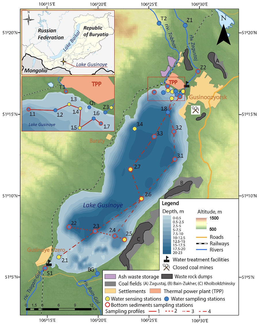
Lake Gusinoye, the second largest lake in the Republic of Buryatia, is a key source of domestic and industrial water supply for the city of Gusinoozersk and nearby areas. It also serves as a recreational site and as a cooling reservoir for the coal-fired Gusinoozerskaya Thermal Power Plant. The lake is exposed to prolonged anthropogenic impact from adjacent pollution sources, including the power plant, overburden dumps of the Kholboldzhinsky coal mine, and a municipal solid waste landfill. This study aims to assess the current hydrochemical state of Lake Gusinoye based on a field survey conducted in July 2019. Sampling of water, suspended matter, and bottom sediments was carried out along three transverse and one longitudinal profiles covering the entire lake area, as well as in inflowing rivers and the plant’s discharge channel. Parameters analyzed included physico-chemical characteristics, major ions, nutrients, heavy metals, and metalloids (HMMs). Aeration of the water column observed during the study period was caused by wind-driven mixing and upwelling, while oxygen depletion was noted near the wastewater discharge zone. Nutrient levels indicated mesotrophic conditions, approaching eutrophic. Wind forcing facilitated a more uniform distribution of water mineralization and major ions across the greater part of the lake’s surface area. Increased water mineralization and sulfate, chloride, and sodium concentrations were confined to the northern part of the lake, where the main anthropogenic sources of readily soluble salts are located. Among HMMs, dissolved Zn, Sr, Mo, and Cu predominated, with maximum concentrations exceeding sanitary norms in the northeastern part of the lake, adjacent to pollution sources. Suspended matter was depleted in HMMs relative to regional lithospheric clarks, whereas bottom sediments showed higher concentrations, indicating continuous pollutant accumulation, especially in the eastern part of the lake.
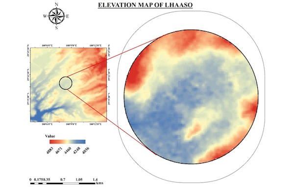
Atmospheric aerosols play a crucial role in modulating Earth’s radiation balance and climate systems, yet they remain a major source of uncertainty in climate modeling. This study aims to characterize aerosol dynamics over the Large High Altitude Air Shower Observatory (LHAASO; 29.36° N, 100.14° E; ~4,410 m above sea level) region by analyzing satellite-based measurements of Aerosol Optical Depth (AOD), Aerosol Index (AI), Single Scattering Albedo (SSA), and Extinction Coefficient (EC) from Moderate Resolution Imaging Spectroradiometer (MODIS), Sentinel-5P, CALIPSO, OMI, and MERRA-2 Reanalysis for the period 2017–2023. The mean AOD peaked at 0.24 ± 0.02, primarily due to long-range dust transport from the Taklamakan and Gobi deserts. The AI varied between 0.68 and 1.26 (standard deviation SD = 0.31 ± 0.26), indicating moderate to significant aerosol activity, particularly during dust events. Aerosol mass concentration (MC) ranged from 4.14 to 31.07 µg/m³ with a SD of 0.67 ± 8.14, reflecting influences from dust transport, meteorological conditions, and local emissions. The EC generally decreased with altitude, consistent with reduced aerosol concentrations and particle sizes. These findings advance our understanding of aerosol behavior in complex terrain and provide essential perspectives for improving climate projections and radiative forcing assessments.
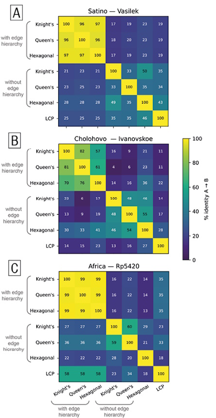
This paper presents a geographic information system (GIS)-based methodology for the automated planning of walking routes in areas with sparse road networks. This approach overcomes the limitations of traditional routing methods that rely solely on either vector road graphs or raster-based cost surfaces by combining both types of representations into a single flexible model. This combined model supports routing on both roads and off-road terrain, taking into account land cover, slope, and movement direction. A hierarchy of network edges prioritizes more passable segments, such as paved roads, while still allowing transitions to natural surfaces where necessary. The methodology has been implemented in ArcGIS Pro and tested using field data from the Satino educational station in the Kaluga region. Three types of regular grid-based network models (square with queen and knight adjacency, and hexagonal) were compared, and routing was simulated under different weather conditions using variable edge weights. The results demonstrate that the square grid with queen adjacency provides the best balance between accuracy and computational efficiency. Compared to the traditional least-cost path (LCP) method, the proposed approach reduces raster-induced distortions and allows for greater adaptability to user preferences. This methodology has practical applications in tourism, environmental research, and emergency route planning, particularly in regions with limited formal transportation infrastructure.
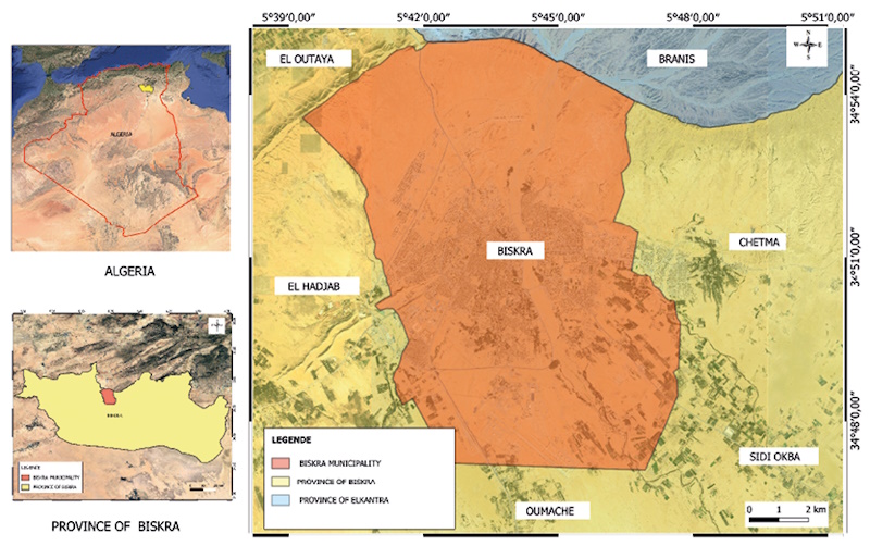
Like many municipalities around the world, Algerian municipalities are faced with the challenge of managing the collection of illegal waste deposits located across their territories. These deposits may occur both at authorized household waste collection points and at unauthorized locations. The management of these deposits presents a challenge, as their handling is incompatible with refuse trucks typically used for household waste collection or because they must be covered by collection services other than those provided by the municipality. It is therefore essential to identify and locate these deposits to ensure appropriate handling.
This article aims to address this issue through an innovative solution that integrates artificial intelligence (AI) into geographic information systems (GIS). The method is based on transfer learning combined with MobileNetV2 to generate a classification model for images of illegal waste deposits at authorized and unauthorized points. This model is integrated into a plugin created with QGIS software to perform image classification, enabling the location and identification of these deposits. The model achieved an accuracy of 98% during training, and its application to images from Biskra municipality illustrates its potential effectiveness. Beyond this case study, the approach offers a scalable and adaptable solution for improving illegal waste deposit management practices in diverse municipal contexts.
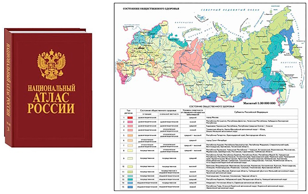
The concept of “health” is a multidimensional phenomenon reflecting the idea of the physical and mental state of the body. This is one of the most important characteristics of society, closely related to economic and social development, demographic structure, the state of the environment, as well as the country’s public health management system. A special place in the information support for solving health problems is given to atlases, primarily those created based on health concepts.
Through the example of some domestic and foreign atlas works, the features of public health mapping are considered. A review of health atlases of various purposes, territorial coverage, and subject matters showed: 1) the concept of “health” is cartographically represented by a significant number of general comprehensive and sectoral atlases; 2) the primary sources of information for preparing atlases and illustrating the concept of “health” remain statistical data; 3) the sections “Demography”, “The Natural and Social Environment”, and “Lifestyle and Risk Factors” are included in virtually all comprehensive health atlases; 4) a comprehensive analysis of regional health determinants and their cause-and-effect relationships requires the integration of supplementary, region-specific data sources; 5) the thematic coverage of atlas-based health mapping is achieved through interdisciplinary collaboration.
The Medico-Geographical Atlas of Russia “Population Health”, currently under development at the Faculty of Geography of Lomonosov Moscow State University, constitutes a continuation of a series of previously published medical-geographical atlases. The conceptual framework of the Atlas is based on new approaches in medical geography, moving “from the geography of disease to the geography of health”.
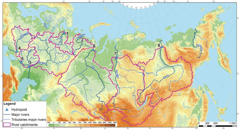
The runoff and climatic characteristics averaged over the basins of major rivers of the East European Plain (Northern Dvina, Pechora, Volga, Don, and Dnieper) and Siberia (Ob, Yenisei, and Lena) under global warming were analyzed. This analysis was based on both observational data and estimates obtained from global climate models (GCMs) under a baseline period (1930s–1980), contemporary global warming conditions (1981–2010), and scenario-based anthropogenic global warming projections into the mid-21st century (2040–2069). The main results suggest that long-term averaged annual runoff estimates derived from an ensemble of 18 CMIP6 GCMs do not accurately reproduce the observed runoff during either the contemporary global warming or baseline periods. Nevertheless, these models generally capture the direction of runoff changes between these two periods, though they tend to underestimate the magnitude of these changes. Consequently, multi-model mean projections are useful in estimating the relative changes in runoff under different global warming scenarios. A key finding of this study is that selecting GCMs that can best reproduce the most reliably observed river runoff and climatic characteristics of river basins under contemporary global warming can improve ensemble model estimates of runoff. In addition, it was found that basin-averaged observed and modeled annual atmospheric precipitation over the Northern Dvina basin, obtained from the RIHMI-WDC archive (after applying all relevant corrections) and multi-model mean data, respectively, were closely aligned. This was in contrast to data of reanalysis and data that only included wetting corrections from the CRU archive.
News
2024-03-07
The GES journal has been ranked as Q1 in the "White list" of peer-reviewed scientific journals
The "white list" is a compilation of scientific journals to be used for evaluating the performance of scientific organizations based on formal criteria. This list includes publications that have been indexed in Web of Science, Scopus, or the Russian Science Citation Index by the middle of the year. It includes 30040 Russian and international scientific journals. The list is published on the special information site of the RCSI.
2024-03-07
THE MOST CITED PAPER 2022

We are pleased to announce that the most cited paper of 2022 in the GES journal is "Mapping Ecosystem Services of Forest Stands: Case Study of Maamora, Morocco", authors Abdelkader Benabou, Said Moukrim, Said Laaribya, Abderrahman Aafi, Aissa Chkhichekh, Tayeb El Maadidi, Ahmed El Aboudi. The paper gained 5 citations according to Scopus database. We cordially wish the authors further scientific success and fruitful collaboration with the GES journal!
2022-12-22
THE MOST CITED PAPER 2021
We are pleased to announce that the most cited paper of 2021 in the GES journal is "Monitoring Land Use And Land Cover Changes Using Geospatial Techniques, A Case Study Of Fateh Jang, Attock, Pakistan" by Aqil Tariq et al. Congratulations!

| More News... |

ISSN 2542-1565 (Online)


