


Contents
Scroll to:
https://doi.org/10.24057/2071-9388-2026-4401
Scroll to:
The concept of “health” is a multidimensional phenomenon reflecting the idea of the physical and mental state of the body. This is one of the most important characteristics of society, closely related to economic and social development, demographic structure, the state of the environment, as well as the country’s public health management system. A special place in the information support for solving health problems is given to atlases, primarily those created based on health concepts.
Through the example of some domestic and foreign atlas works, the features of public health mapping are considered. A review of health atlases of various purposes, territorial coverage, and subject matters showed: 1) the concept of “health” is cartographically represented by a significant number of general comprehensive and sectoral atlases; 2) the primary sources of information for preparing atlases and illustrating the concept of “health” remain statistical data; 3) the sections “Demography”, “The Natural and Social Environment”, and “Lifestyle and Risk Factors” are included in virtually all comprehensive health atlases; 4) a comprehensive analysis of regional health determinants and their cause-and-effect relationships requires the integration of supplementary, region-specific data sources; 5) the thematic coverage of atlas-based health mapping is achieved through interdisciplinary collaboration.
The Medico-Geographical Atlas of Russia “Population Health”, currently under development at the Faculty of Geography of Lomonosov Moscow State University, constitutes a continuation of a series of previously published medical-geographical atlases. The conceptual framework of the Atlas is based on new approaches in medical geography, moving “from the geography of disease to the geography of health”.
Malkhazova S.M., Kotova T.V., Orlov D.S., Komilova N.K., Safarova N.I., Wang L. The Concept of Health in Atlas Mapping. GEOGRAPHY, ENVIRONMENT, SUSTAINABILITY. 2026;19(1):152-166. https://doi.org/10.24057/2071-9388-2026-4401
The concept of “health” is a multidimensional phenomenon reflecting the physical and mental state of an organism (Petkau 2015). When applied to the population of a country, region, or specific administrative territory, the concept of “health” is interpreted as “public health” (Prokhorov 2001). This is one of the most crucial characteristics of society as a social organism: its potential for continuous harmonious growth and socioeconomic development. Public health serves as the most striking and comprehensive indicator of living conditions, as it largely determines the demographic and economic development of individual states and territories.
In recent years, public health has emerged as a strategic priority within state policy for numerous nations. As emphasized by the renowned cardiac surgeon Leo Bokeria at the “Health of the Nation – the Foundation of Russia’s Prosperity” forum, “Health is not just medicine. It is infrastructure, lifestyle, and even politics...”. Public health is closely linked to economic and social development, demographic structure, morbidity, environmental conditions, and the national public health management system (Lisitsyn and Sakhno 1989; Matros 1992; Lisitsyn and Ulumbekova 2011; Medik and Yuryev 2016). While the concept is multifaceted, several core principles are widely acknowledged:
In recent years, the public health system in our country has become a national priority. According to the Russian Minister of Health, creating a public health system has become “a task not only for federal, regional, and municipal structures, but also for public associations, volunteer movements, and the media. Such a system must become a kind of network operating at all levels and encompassing all areas of human life”.
The national projects for 2025-2030 include the “Long and Active Life” project. This project is a successor to the “Healthcare” project and aims to develop and implement a comprehensive program to protect maternal and reproductive health and increase life expectancy in rural areas. The goal of the national project is to increase life expectancy to 78 years by 2030 and to 81 years by 2036, including accelerated growth in healthy life expectancy indicators.
Comprehensive public health information is crucial for both the development and evaluation of healthcare efforts, determining their effectiveness, and addressing population health issues across individual, group, and societal levels.
With various information sources available, including statistical publications, census and medical examination results, sociological surveys, expert assessments, databases, and annual reports from international organizations such as the WHO and World Bank, etc., comprehensive atlases, primarily those based on health concepts, play a pivotal role in providing information, taking into account the specific characteristics of the mapping object.
The Medico-Geographical Atlas of Russia “Population Health” is currently under development at the Faculty of Geography at Lomonosov Moscow State University. This atlas continues a series of previously published medico-geographical atlases of Russia (Natural Focal Diseases 2015, 2017; Healing Springs and Plants 2019; Risk Factors for Oncological Diseases 2024).
The purpose of this paper is to provide an overview of the main traditional atlases and to prepare the scientific and methodological foundation for the development of the Medico-Geographical Atlas of Russia “Population Health”.
The objectives of this article are:
In pursuit of the stated objectives, a systematic examination of domestic and international atlases was conducted. The selection criteria ensured a representative sample across various purposes, geographical scales, and thematic orientations to investigate the conceptualization of “health”. Source materials, procured in both print and digital formats from the Russian State Library and online databases, were analyzed in conjunction with a critical review of the relevant academic literature.
As a key societal characteristic, public health in Russian mapping is a necessary subject of study in comprehensive national and regional atlases.
The National Atlas of Russia (2007) contains health maps, primarily in the sections “Population and Social Development” (Population Reproduction; Birth Rate; Mortality; Life Expectancy; Population Health, including Public Health Status, Population Morbidity subsections) and “Social Sphere” (Healthcare: Organization of Medical and Preventive Care for the Population; Medical Personnel: Physicians; Nursing Personnel; Healthcare Financing subsections). Collectively, these provide a comprehensive assessment of population health across more than 90 indicators. Among these, the composite map of “Public Health Status” (Fig. 1) is of particular interest.

Fig. 1. Map “State of public health”. Scale 1:60,000,000
A significant amount of information on public health is presented in the comprehensive Ecological Atlas of Russia (2017). This resource features cartographic representations of socially significant and natural focal diseases, mortality rates, and a composite “Public Health Index”. The latter is accompanied by a textual analysis detailing population health status across the regions of the Russian Federation (Fig. 2).

Fig. 2. Map “Public Health Index”. Scale 1:40,000,000
Individual population health maps (Morbidity, Mortality, Healthcare System) can be found in general comprehensive regional atlases (Chistobaev and Semenova 2013). For illustrative purposes, a representative map from the Atlas of the Baikal Region: Society and Nature (2021) is provided (Fig. 3).
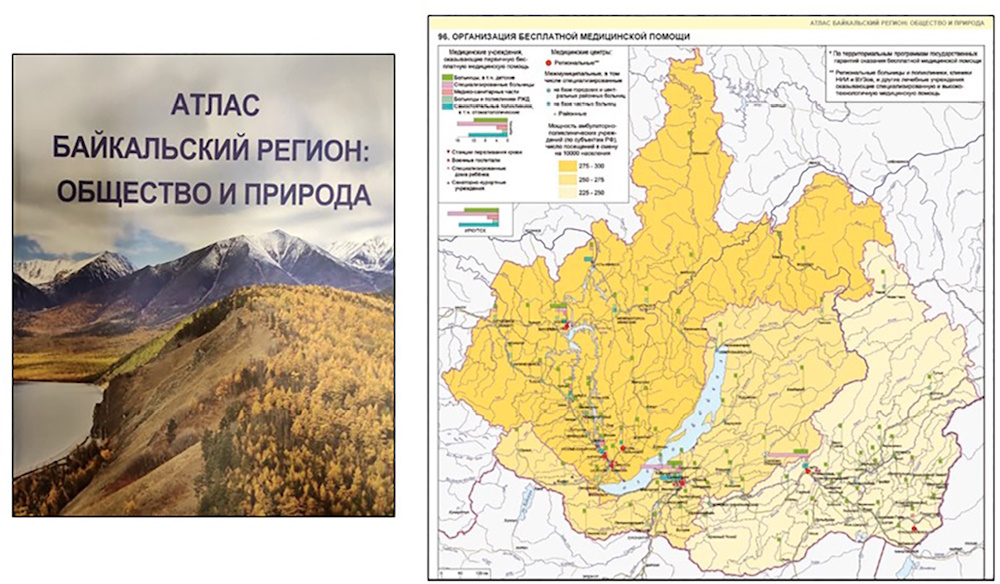
Fig. 3. Map “Organization of free medical care”. Scale 1:6,000,000
In domestic mapping, public health has emerged as a distinct thematic focus in a series of specialized and comprehensive national and regional atlases (Fig. 4). The following section provides a detailed examination of these cartographic works.

Fig. 4. Examples of Health atlases
Of the national-level thematic atlases documenting the health status of the country’s population, the Atlas of Health of Russia is particularly noteworthy. To date, it remains the only national-level publication that is unique in the comprehensiveness of its health indicators. Published on an almost annual basis since 2005, the most recent iteration, Issue 15, was released in 2019 (Atlas. Health of Russia 2019). The Atlas is based on extensive statistical information provided by the “League of the Nation’s Health.” According to its developers, it is intended for Russian citizens, with a primary focus on regional administrators at various levels, for whom it serves as a tool for situational monitoring and evidence-based decision-making. It is also intended for a broad spectrum of users engaged in professional and public activities related to disease prevention, environmental improvement, and the mitigation of adverse social phenomena, as well as for any individuals with an interest in the contemporary state of the national healthcare system.
The Atlas presents key indicators for the demographic and socioeconomic development of the Russian Federation, healthcare, and environmental impacts. Each annual edition significantly expands the scope of traditional sections (Demography, Morbidity, Resource Provision for Healthcare Organizations, Factors Affecting Population Health). For example, “Section 12. Socioeconomic Indicators in the Russian Federation” displays over 40 indicators, grouped into subsections: Living Standards, Employment, Pension Provision, Living Conditions, Agricultural Production, and Agricultural Product Consumption.
As a rule, new sections are added annually: Development of Physical Culture and Sports, Crime as a Threat to Health and National Security, Penitentiary Medicine, etc. Issue 15 contains over 230 maps, grouped into 16 sections; for comparison, the initial editions contained only 6 to 8 sections.
The data within the Atlas are conveyed through a combination of cartograms, constructed from multi-year statistical datasets, table data, line diagrams, and explanatory text. A notable example in this domain is Russia’s first atlas on this subject, “The Environment and Health of the Population of Russia” (1995). This comprehensive work, produced in both print and digital formats in Russian and English, is structured into eight chapters: 1) Russia and its Population; 2) The Natural Environment and Biophysical Factors of Population Life Support; 3) The Economic and Technical Complex and its Impact on Living Conditions; 4) Social Processes and their Impact on Public Health; 5) Population Morbidity in Russia; 6) Disability; 7) Mortality; and 8) Life Expectancy, as well as a Conclusion section. Each chapter is further subdivided into two to seven thematic subchapters. An innovative cartographic representation from the subsection “4.1. The Structure and Stability of Society in the Regions of Russia” is illustrated in Fig. 5.

Fig. 5. Map “Balance (harmony) of the population structure by gender, age, migration mobility (points)”
The concluding section, “Development of a List of Population Health Indicators Related to the State of the Environment for Use in Databases for Assessing the Impact of the Environment on Health” delineates the core requirements for such indicators and offers specific recommendations for metrics related to population health, as well as the quality of atmospheric air, drinking water, and the water supply system.
The content is presented using cartograms at a scale of approximately 1:60,000,000, supplemented by diagrams, textual analyses, and tables. The temporal scope of the data varies, with the maximum coverage spanning the period from 1980 to 1996.
Among the regional health atlases, the medical and geographical atlases of Yakutia are of significant interest. In 2005, the Medico-geographical Atlas of Population Health and Healthcare in the Republic of Sakha (Yakutia) at the Turn of the Century was prepared, followed by the Medico-geographical Atlas of Population Health Protection in the Republic of Sakha (Yakutia) in 2012. The former contains more than 85 maps, distributed across the following sections: 1. Medical-Demographic Situation (6 indicators); 2. Population Morbidity and Disability (24 indicators); 3. Healthcare Resource Provision (8 indicators); 4. Healthcare Institution Activities (13 indicators); 5. Treatment and Preventive Institutions across 35 uluses (districts). Population susceptibility to various diseases is represented by two distinct metrics: prevalence and incidence (Fig. 6).
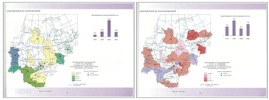
Fig. 6. Maps “Incidence of drug addiction” and “Incidence of toxicomania”. Scale 1:15,000,000
The second atlas contains 164 maps characterizing the socio-demographic situation, population morbidity, and the activities of medical and preventive care, and physical education and health facilities in the administrative-territorial units of the Republic of Sakha (Yakutia) – uluses (districts). These indicators are assessed and compared with similar indicators for the Russian Federation and the Far Eastern Federal District.
A separate publication, The Atlas of Population Health of the Astrakhan Region (2010), provides a focused analysis on maternal and child health, alongside region-specific environmental determinants. Its structure is organized into six thematic sections: 1) Demographic Situation; 2) Population Morbidity; 3) Children’s Health; 4) Microelement and Vitamin Content in Children’s Bioenvironments; 5) Women’s Health; 6) Risk of Environmental Factors on Population Health. The final section is of particular relevance, as it quantifies critical regional health challenges, including the toxic and carcinogenic risks associated with atmospheric chemical exposure and the public health hazards of drinking water contamination (Fig. 7). The district cartograms are supplemented with diagrams and text descriptions.
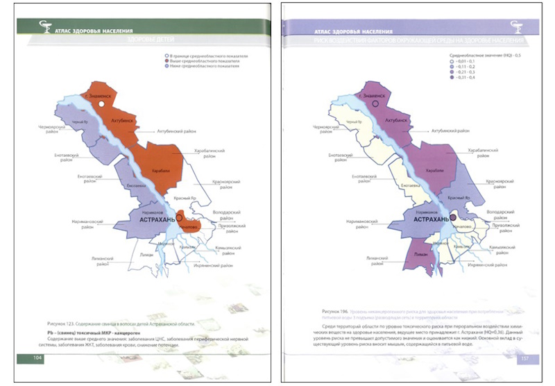
Fig. 7. MCartograms “Level of non-carcinogenic risk to public health when consuming drinking water of the 3rd rise of distribution network” and “Lead content in children’s hair”
Significant attention in the study and regional mapping of population health is devoted to specific disease categories, such as mental health disorders (Fig. 8).

Fig. 8. Atlases of mental health of the population
The International Association of Ethnopsychologists and Ethnopsychotherapists (IAEE), the concept of which belongs to RAMS Academician V. Ya. Semka, has been instrumental in advancing this field of study. A principal contribution of the IAEE has been the systematic development of a series of regional atlases, including those for Siberia and the Far East (1988), the Republic of Buryatia (2007), Tomsk (2008), Kemerovo (2011), Omsk (2012) regions, as well as Zabaikalsky Krai (2020).
The structure of these atlases is exemplified by the Atlas of Mental Health of the Kemerovo Region. This publication is organized into five chapters: 1) Historical, climatic, geographic, and socioeconomic characteristics of the region, including psychiatric services; 2) Prevalence of mental disorders and schizophrenia across administrative territories; 3) Prevalence of non-psychotic mental disorders and mental retardation; 4) Mental disorders in children and adolescents; and 5) The regional drug addiction situation.
Examples of cartograms for the Kemerovo Region and the Zabaikalsky Krai are shown in Fig. 9.

Fig. 9. a) Atlas of mental health of the population of the Kemerovo region. Cartogram “Indicators of the overall incidence of mental disorders in 2009 (per 100,000 population)”; b) Atlas of mental health of the population of Zabaikalsky Krai. Cartogram “Primary incidence of all mental disorders in the districts of Zabaikalsky Krai for 2019 (per 100,000 population)”
As previously noted, the study of disease prevalence necessitates the consideration of a multifactorial framework of environmental determinants. This includes not only sociodemographic and sociocultural factors but also ethnocultural and ethnoecological variables.
Natural focal diseases are a serious threat to public health. The researchers from the Faculty of Geography at Lomonosov Moscow State University have made significant contributions through the publication of the Medical and Geographical Atlas of Russia “Natural Focal Diseases” (2015, 2017). This atlas represents the first comprehensive cartographic compilation of data on diseases whose pathogens circulate independently of humans within natural ecosystems. The significance of this work is substantial, particularly given the vast, sparsely populated, and underdeveloped territories of Russia. An illustrative map from this atlas is provided in Fig. 10.

Fig. 10. Map “Tick-borne encephalitis distribution”. Scale 1:30,000,000
Another notable contribution is the Atlas of the Most Important Natural and Social Health Risks in the Orenburg Region (2005), designed to facilitate an in-depth analysis of population health determinants in relation to natural, geochemical, and anthropogenic risks. The atlas is divided into two parts. Part One comprises eight chapters: 1) Medical and demographic mapping by iodine deficiency parameters (Fig. 11a); 2) Medical and demographic mapping by iron deficiency in nutrition; 3) Medical and demographic mapping by parameters of the risk of premature death from poisoning by alcohol and surrogates; 4) Medical and demographic mapping by the indicator of physical violence in society (Fig. 11b); 5) Medical and demographic mapping by the indicator of mental health; 6) Medical and demographic mapping of fluorine deficiency; 7) Ecological and hygienic characteristics of trends in the dynamics of the most important natural and social health risks; 8) Ecological and hygienic ranking of risk based on average long-term data. Part Two contains four chapters providing methodological explanations for the mapping of demographic processes, primary morbidity, and leading causes of mortality, alongside a hygienic characterization and territorial ranking based on these indicators. The analysis covers the period from 1995 to 2004.

Fig. 11. a) Cartogram of the prevalence of iodine deficiency in the Orenburg Region in the last year (1995) of directive prevention; cartogram of the prevalence of iodine deficiency in the Orenburg Region in 1996. b) Cartogram of the risk of death from accidental poisoning by alcohol and its surrogates of the population of the Orenburg Region in 2003; cartogram of the risk of death from physical violence in the Orenburg Region in 1993
More recently, the scope of cartographic research on risk factors has been expanded by the Medical and Geographical Atlas of Russia “Risk Factors for Oncological Diseases” (2024), also created by the Faculty of Geography at Lomonosov Moscow State University. The relevance of this publication is underscored by the critical status of public health in Russia and the prominent role of cancer among the leading causes of mortality. The atlas presents a broad classification of risk factors, systematically organized into the following sections: 1) Prerequisites for Cancer (Demography, Health, Natural Conditions, Socioeconomic Determinants); 2) Key Risk Factors (Environment, Lifestyle, Living and working conditions, Occupational risks, Infectious agents); 3) Prevalence and Mortality from Malignant Neoplasms; and finally; 4) Risk Factor Mitigation and Cancer Prevention (Oncology service infrastructure, Use of natural resources for treatment, Public prevention initiatives, and Regional policy directions). A representative map from this atlas is shown in Fig. 12.

Fig. 12. Map “Smoking prevalence. 2021”
Some of the key public health indicators (primarily demographic, such as life expectancy at birth, mortality; also incidence, etc.) are reflected in a number of regional medical-demographic, medical-geographical, and medical-ecological atlases. These include the following atlases: Medical-Demographic Atlas of the Kaliningrad Region (2007); Medical-Demographic Atlas of the Moscow Region (2007), Medical-Geographical Atlas of the Smolensk Region (2012), and Medical-Ecological Atlas of the Voronezh Region (2010) (Fig. 13). The atlases are structured in four sections: 1) Introductory; 2) Population and Social Conditions; 3) Population Health; and 4) Health Care. The Environmental Quality section of the Medical and Ecological Atlas of the Voronezh Region contains approximately 20 maps that display medical and demographic processes, general population morbidity, incidence of specific disease classes, the frequency of reproductive pathologies, nutritionally induced diseases, and some particularly dangerous natural focal infections, etc.

Fig. 13. Regional atlases
Globally, the field of population health has been increasingly documented through a series of specialized atlases. A discernible trend in this domain is the shift towards electronic publications, which facilitate the recording, processing, and dynamic updating of extensive datasets.
Traditional atlas cartographic studies are an important tool in studying and assessing Chinese population health, consistently used to address pressing health-related issues. A substantial number of atlases have been developed to date, exhibiting considerable diversity in their thematic scope. This review will highlight several seminal atlases without an exhaustive structural analysis.
The severity of oncological disease problems became the basis for studying their distribution and preparing a number of atlases (Fig. 14).
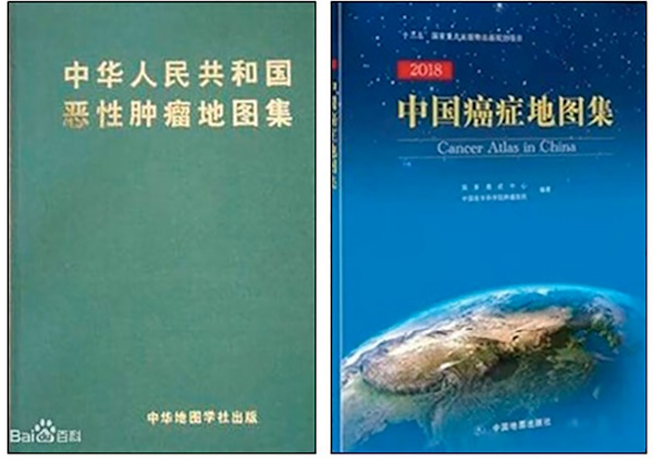
Fig. 14. The Atlases of Cancer Mortality in the People’s Republic of China
The Atlas of Cancer Mortality in the People’s Republic of China (1979) represents a foundational bilingual (Chinese-English) publication. It was constructed from a nationwide cause-of-death survey (1973-1975) encompassing 29 provincial-level administrative regions and a population of 850 million. Utilizing mathematical models and classification indices, the atlas delineated the geographical distribution of 15 malignant tumors across 2,392 county-level units. This work systematically identified, for the first time, high-risk geographical patterns for cancers such as oesophageal and nasopharyngeal carcinoma. The analytical frameworks established in this atlas provided a foundation for oncological research over the subsequent three decades.
In subsequent years, systematic work has been underway to create cancer atlases. In 2015, an updated county-level atlas (China Cancer Atlas 2015) was published, coordinated by the Cancer Institute of the Chinese Academy of Medical Sciences in collaboration with the Institute of Geographic Sciences and Natural Resources Research (IGSNRR CAS) and the National Center for Chronic and Noncommunicable Diseases Control and Prevention (CDC). It combines data from the national tumor registry, three rounds of mortality surveys, and demographic statistics. The atlas depicts the geographic distribution of major cancer types in China, providing reliable scientific data for interdisciplinary research, early diagnosis/treatment, and optimization of healthcare resource allocation. The atlas serves as a basis for medium- and long-term chronic disease prevention strategies in China and provides data to the WHO and the International Agency for Research on Cancer (IARC).
Much attention is paid to the study and mapping of endemic diseases (Fig. 15). The Atlas of Endemic Diseases and the Environment of the People’s Republic of China (1989) was created as part of an interdisciplinary project (1980–1988) supervised by a joint committee of the Ministry of Health and the Chinese Academy of Sciences. It synthesizes geographic data on four major endemic diseases (Keshan disease, Kashin-Beck disease, endemic goitre / cretinism, and fluorosis) with environmental factors on 221 maps at the national, regional, and local levels. It constituted a milestone in medical geography by innovatively establishing linkages between geochemical imbalances and disease etiology, thereby informing subsequent policy and research directions.

Fig. 15. The Atlases of endemic diseases in the People’s Republic of China
Research on population-based diseases continued and was reflected in the Atlas of Endemic Diseases of China (2020). The atlas is a national publication project of the 14th Five-Year Plan (2021-2025) and documents China’s public health campaigns against endemic diseases (including Keshan disease, Kashin-Beck disease, iodine deficiency/excess disorders, fluorosis, and arsenic poisoning) from 1949 to 2020, employing multi-scale mapping, dynamic surveillance data, and elimination assessments.
An example of a regional-level atlas of endemic diseases is the Atlas of Endemic Diseases of Yunnan Province (1989). It was compiled by a group of medical and geographic experts organized by the Yunnan Provincial Health Department. Published by the People’s Medical Publishing House in 1989, the atlas includes introductory maps, 66 distribution maps for diseases such as Keshan disease, endemic goiter and cretinism, fluorosis, and brucellosis, as well as 18 supplementary maps. It comprehensively, systematically, and clearly depicts the distribution patterns, epidemic patterns, regional differences, and the relationship with the geochemical environment of four human malaria pathogens – Plasmodium falciparum, Plasmodium vivax, Plasmodium malariae, and Plasmodium ovale. The atlas holds both theoretical and practical significance.
The Atlas of Major Endemic Diseases and Geoecology of the Tibetan Plateau was published in 2025. It summarizes and reflects the relationships between the major geochemical endemic diseases of the Tibetan Plateau and the chemical, natural, and anthropogenic environments. It also examines the effectiveness of prevention and control measures. This atlas provides an overview of the spatiotemporal patterns of plague epizootics in the Himalayan marmot population on the Tibetan Plateau since the 1950s, revealing the ecological characteristics of natural plague foci and the extent to which they have changed due to human activity. The atlas consists of five sections (Introduction; Distribution of Kashin-Beck Disease; Distribution of Endemic Fluorosis; Environmental Arsenic Exposure and Risk; Plague Epidemic Patterns and Ecological Characteristics of Himalayan Marmots).
A consistent study of natural focal diseases served as the basis for the development of several epidemiological atlases of China (Fig. 16).

Fig. 16. Epidemiological Atlas of Natural Focal Diseases of China. Atlas of Plague and the Environment of the People’s Republic of China. Atlas of Schistosomiasis in China
The sustained investigation of natural focal diseases has similarly yielded significant cartographic outputs, notably the three-volume Epidemiological Atlas of Natural Focal Diseases of China (2019) and the bilingual Atlas of Plague and the Environment of the People’s Republic of China (2000). The former comprises over 1,600 maps detailing the distribution of 33 natural focal diseases, one vector-borne disease, and more than 1,100 host and vector species (encompassing 158 pathogens) across 2,900 counties. It provides a systematic categorization of disease-environment interactions, host/vector distributions, and complex epidemiological patterns. The latter atlas analyzes over two centuries of plague epidemiology in China through 284 maps and diagrams, covering spatiotemporal dynamics, natural foci, host/vector ecology (rodents and fleas), Yersinia pestis biotypes, and historical control measures.
The Atlas of Schistosomiasis in China (2012) delineates the prevalence of schistosomiasis, including human and bovine infection rates, and the distribution of intermediate host snails, detailing their geographic extent, density, and infection rates at national and key regional levels.
The relationship between public health and the environment is further expanded on in the Atlas of Climate Risks to Health (2021), which operates at the provincial scale. This publication monitors over 20 indicators of climate-related health impacts and tracks the progression of climate change adaptation initiatives throughout China (Fig. 17).
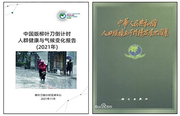
Fig. 17. Atlas of Climate Risks to Health
A broader contextualization of public health is presented in the Atlas of Population, Environment, and Sustainable Development of the People’s Republic of China (2000). This work integrates health metrics with a comprehensive set of environmental and socioeconomic indicators. Its 184 maps, organized into nine thematic sections, combine demographic trends, environmental pressures (including land, water, and air pollution), and regional sustainable development strategies.
The Atlas of the Elderly Population of the People’s Republic of China published in 1986. It is a 224-page compendium derived from national census data. It delineates age-group distributions across 46 categories (e.g., 60+, 65+, 80+, 90+, 100+) at the county level, complemented by foundational maps of socioeconomic and environmental conditions (Fig. 18).

Fig. 18. Atlas of the Elderly Population of the People’s Republic of China. Atlas of Gender Equality and Women’s Development in China. Atlas of Child Nutrition and Health in China
Addressing a critical research gap, the Atlas of Gender Equality and Women’s Development in China (2010) represents one of the first national atlases on this subject. Its eight sections of cartographic representations systematically assess gender equality across domains, including politics, employment, education, healthcare, marriage and family, and environmental contexts.
A more recent and distinctive contribution is the Atlas of Child Nutrition and Health in China (2024). Its 144 maps are systematically divided into six sections (Overview, Dietary Nutrition, Growth and Development, Malnutrition, Physiology / Metabolism, and Knowledge / Behavior), providing detailed data on infant feeding practices, nutrient intake, physical and mental development, undernutrition, obesity, metabolic indicators (e.g., blood pressure, lipids, glucose), and associated lifestyle factors.
Multifaceted medico-geographical research is being conducted in the Republic of Uzbekistan. The results are presented in several atlases.
The Medico-Geographical Atlas of the Republic of Uzbekistan (O΄zbekiston respublikasining…) includes three parts: 1) Syrdarya and Jizzakh Regions, 2022; 2) Tashkent and Tashkent Region, 2024; 3) Republic of Karakalpakstan and Khorezm region, 2025 (Fig. 19). Part 1, consisting of 87 maps, reflects the nosoecological situation at national and regional scales. For Uzbekistan as a whole, in addition to traditional introductory maps (Natural Conditions, Political and Administrative Structure, Population, etc.), there are demographic maps, mortality (4 maps), morbidity (21 maps), and healthcare system maps (for example, Number of employees in sanatorium-resort institutions, Outpatient and Polyclinic Institutions in Uzbekistan, Activities of Hospital Institutions in Uzbekistan, Activities of Obstetrics and Gynecology Departments, Service Network, etc.). For the regions, in addition to introductory maps displaying the main geographic factors influencing the health of the population, morbidity maps are provided. At the same time, attention is focused on diseases that are socially significant or specific to these regions due to a number of natural, ethnic, and other factors.

Fig. 19. Atlas of the Republic of Uzbekistan. Part 1. Syrdarya and Jizzakh regions; Part 2. City of Tashkent and Tashkent region; Part 3. Republic of Karakalpakstan and Khorezm region
Part 2 presents nosogeographic maps of Tashkent and the Tashkent region and focuses on Tashkent and the Tashkent Region, with a thematic emphasis on “diseases of civilization” prevalent in urban settings: incidence of neoplasms, endocrine diseases, nutritional diseases, metabolic disorders, blood and hematopoietic diseases, diseases with certain immune system disorders, mental and behavioral diseases, diseases of the nervous system, circulatory system, and respiratory organs. Several environmental maps of Tashkent city and region have also been created: 1) Green spaces; 2) Air pollution (TVOC, total volatile organic compounds), noise; 3) Drinking water supply to apartments (houses); 4) Atmospheric air monitoring; 5) Air pollution (PM2.5; PM10); 6) Air pollution (CO; CO2).
Part 3 is intended to reflect the geoecological situation of the region, as well as the dynamics of individual classes of diseases in the context of climate change, through nosogeographic maps of the Republic of Karakalpakstan and the Khorezm region, covering regional morbidity, the incidence of certain infectious and parasitic diseases, and the incidence of tuberculosis, viral hepatitis, scarlet fever, salmonella infections, measles, and bacterial dysentery.
Work is currently underway on Part 4 of the atlas. Part 4 focuses on the medical and geographical situation of the Kashkadarya and Surkhandarya regions. This atlas primarily includes information on the epidemiological situation and the geographic distribution of infectious and parasitic diseases.
Active research on health and health systems in a wide variety of areas, with the results documented in atlases, is conducted at both the country and global levels, primarily under the auspices of the WHO and other international organizations. For the purposes of this paper, we will limit ourselves to examples of global atlases covering various topics.
The Global Health Atlas is a unified electronic platform that compiles standardized data and statistics on infectious diseases at the country, regional, and global levels for analysis and comparison. Data analysis and interpretation are complemented by information on demographics, socioeconomic conditions, and environmental factors. The Atlas highlights the wide range of factors influencing the spread of infectious diseases. This multi-year database focuses on key poverty-related diseases (malaria, HIV/AIDS, tuberculosis, etc.), as well as diseases on the path to eradication (dracunculiasis, leprosy, lymphatic filariasis), epidemic and emerging infections (meningitis, cholera, yellow fever), and drug resistance. In addition to epidemiological information, the system provides data on key support services, such as the network of Centers for Disease Control and Prevention, the Global Outbreak Alert and Response Network, and others. The database is constantly updated.
The Surveillance Atlas of Infectious Diseases was prepared by the European Centre for Disease Prevention and Control. The atlas contains data (for subpopulations: confirmed cases and data quality; indicators: registered cases, notification rate, age-standardized rate, hospitalized cases, number of deaths, proportion of cases associated with travel, etc.; and time) on more than 60 infectious diseases. The interface allows users to interact with the data, creating various maps and tables that provide an overview of the status of various infectious diseases in European countries.
Further advancing this field, the Atlas of Population Health in the European Union Regions (Atlas of Population Health in European… 2017) employs a composite metric, the Population Health Index (PHI), to provide a multidimensional assessment of European population health (Fig. 20). The atlas presents regional-level data across 17 health dimensions, such as employment and income, social protection, education, demographic change, health behaviors, environmental pollution, housing conditions, infrastructure, health system resources, expenditure, efficiency, and mortality and morbidity. The PHI itself is constructed from 39 indicators deemed relevant for a comprehensive assessment at the European level, supplemented by analyses of 22 additional indicators. The atlas is structured in three parts: 1) a foundation of theoretical and methodological considerations; 2) cartographic representations of the PHI across European regions; and 3) an analysis of regional inequalities in the determinants of population health. This final section is further divided, providing detailed data on the 39 PHI indicators and contextual information from the supplementary indicators to elucidate the geographic patterns of the population health index.

Fig. 20. Atlas of Population Health in the European Union Regions
Among specialized international atlases, the mental health atlases periodically produced by the World Health Organization (WHO) are noteworthy. They are considered the most comprehensive sources of information on mental health worldwide and an important tool for developing and planning mental health services in countries and regions. The first edition was published in 2001. The main goal of the atlases is to collect information on policies, plans, financing, human resources, and the provision of mental health services in different countries, as well as health monitoring and evaluation. Data is collected through a questionnaire sent to the health authorities of each country.
By providing governments and stakeholders with comprehensive data on mental health systems, services, and resources in different countries, the atlases help identify gaps and opportunities for improving mental health measures worldwide. The frequency of updates depends on the availability of data and resources, as well as the demand for new information. Typically, the update cycle is three years. For example, the Mental Health Atlas 2024 consists of five sections: 1) Mental Health Information Systems and Research; 2) Mental Health System Management; 3) Financial and Human Resources for Mental Health; 4) Access to and Use of Mental Health Services; and 5) Mental Health Promotion and Prevention. The content is presented through diagrams and text (Fig. 21). The publication is particularly important because it includes information and data on progress towards achieving the goals and targets of the Comprehensive Mental Health Action Plan for the period from 2013 to 2030.
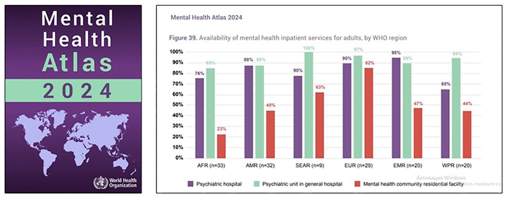
Fig. 21. Availability and reporting of mental health data in responding countries, by WHO regions
The Atlas of Health and Climate (2012) was prepared by the World Health Organization and the World Meteorological Organization. It contains information on the links between weather, climate, and major health issues. The range of issues covers diseases caused by poverty, emergencies resulting from extreme weather events and epidemic outbreaks, as well as environmental problems. The influence of other factors on the relationship between health and climate is noted, such as psychology and individual behavior, environmental and socioeconomic conditions of the population, and the coverage and effectiveness of health programs. The atlas consists of three sections with subsections: 1) Infections (Malaria, Diarrhoea, Meningitis, Dengue Fever); 2) Emergencies (Floods and Cyclones, Drought, Airborne Hazards); 3) Emerging Environmental Issues (Heat Stress, UV Radiation, Pollen, Air Pollution). A representative map from this atlas is provided in Fig. 22.
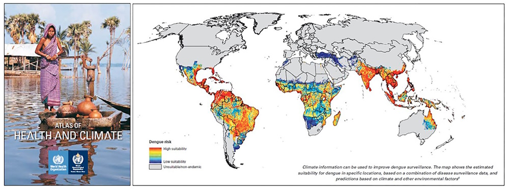
Fig. 22. Map of the spread of dengue fever depending on climatic conditions and other factors
As noted above, in addition to printed publications, online atlases dedicated to population health are currently being created. For example, in the United States, a significant number of atlases have been prepared, covering various geographic and thematic areas. They present many indicators that determine the structure of healthcare and population health. One of the most well-known projects is the Dartmouth Atlas (www.dartmouthatlas.org). The project was created by the Dartmouth Institute for Health Policy and Clinical Practice and operated from 1996 to 2024. The project provides comprehensive information and analysis at the national, regional, and local levels on the distribution and use of medical resources, identifying differences in the efficiency and effectiveness of healthcare across the country, including individual hospitals (capacity, utilization, costs, and outcomes) and their physicians. It uses data from various federal agencies, the American Hospital Association, and the American Medical Association. It includes maps, figures, and tables on topics such as physician personnel and the diagnosis and treatment of various diseases.
There are also other electronic health atlases, both for individual countries and regions. A detailed review of them requires a separate study. A number of atlases can be found on the Dartmouth Atlas website.
In a related development, the Faculty of Geography of Lomonosov Moscow University has initiated the development of the Medico-Geographical Atlas of Russia “Population Health”. This project is founded upon a review of existing domestic and international health atlases and builds upon the faculty’s prior experience in producing medical-geographical atlases (e.g., Natural Focal Diseases 2015, 2017; Healing Springs and Plants 2019; Risk Factors for Oncological Diseases 2024).
As noted above, the concept of the Atlas is based on new approaches in medical geography of moving “from the geography of diseases to the geography of health”. This approach prioritizes the identification and cartographic representation of conditions and factors that contribute to enhanced public health, highlighting positive vital statistics such as high life expectancy, centenarian prevalence, and low rates of morbidity, mortality, and disability.
The preliminary structure of the atlas is organized into six sections: 1) Introduction; 2) Medical and Demographic Situation; 3) Socioeconomic Conditions and Lifestyle; 4) Health-improving Potential of the Environment; 5) Healthcare; 6) Tactics and Strategy of Actions to Improve Population Health.
A review of atlases with diverse scopes, territorial coverages, and thematic objectives yielded the following findings:
1) Being the most important characteristic of society, public health is a necessary subject of study in global, national, and regional atlas mapping.
2) The concept of “health” is represented by a significant number of general comprehensive and sectoral atlases. Along with traditional atlases, there is a clear trend toward electronic publications.
3) The set of indicators and the completeness of the “health” concept’s representation vary depending on the purpose, concept of the atlas, and the completeness of the information base. Research continues to identify the dominant health factors and objectify its assessment.
4) Standardized sections, such as “Demography”, “Natural and Social Environment”, and “Lifestyle and Risk Factors” are included in virtually all health atlases.
5) The principal information sources for atlas compilation remain statistical data, which are primarily visualized through cartograms and schematic diagrams. These datasets form the foundation for subsequent spatial analysis and modeling to highlight cause-and-effect relationships. Along with traditional methods of representation, there is a widespread use of infographics. Cartographic representations are typically supplemented by explanatory text and table data.
6) A more comprehensive representation, analysis, and interpretation of cause-and-effect relationships in population health at the regional scale is facilitated by the integration of supplementary, region-specific information sources, alongside expert assessments and population survey data.
7) The thematic breadth, analytical depth, and conceptual focus of health mapping in atlases are achieved through an interdisciplinary methodology. This approach engages collaboration of medical geographers and specialists from other scientific fields at the intersection of medicine, ecology, and geography.
The creation of the Medico-Geographical Atlas of Russia “Population Health” at the Faculty of Geography of Lomonosov Moscow University, in a series of previously created medical-geographical atlases, should contribute to the information support for solving public health problems and improving the country’s healthcare system.
1. Atlas of Cancer Mortality in the People’s Republic of China. (1979). Office of Cancer Prevention and Control Research, Ministry of Health, Chinese Cartography Society, 99 p.
2. Atlas of Child Nutrition and Health in China. (2024). Zhao Wenhua, Li Shujuan, Yang Zhenyu, Zhang Qian, China Map Press, 150 p.
3. Atlas of Health and Climate (2012). WHO, WMO. 64 p.
4. Atlas of health in Europe. 2nd edition, (2008), 128 p.
5. Atlas of health of the population of the Astrakhan region. (2010). Astrakhan: Medical expert center: Volga, 159 p. (in Russian)
6. Atlas of key endemic disease and geo-environment in Tibet Plateau. (2025). Yang Linsheng, Gong Hongqiang, Zhang Qiang., Sinomap press, Beijing.
7. Atlas of mental health of the population of Kemerovo region. (2011). Tomsk, Kemerovo, 100 p. (in Russian)
8. Atlas of mental health of the population of Omsk region. (2012). Tomsk, Omsk, 132 p. (in Russian)
9. Atlas of mental health of the population of the Republic of Buryatia. (2007). Tomsk, Ulan-Ude, 140 p. (in Russian)
10. Atlas of mental health of the population of the Zabaikalsky Krai. 2nd ed. revised and enlarged. (2020). Novosibirsk: DEALSIB, 128 p. (in Russian)
11. Atlas of mental health of the population of Tomsk region. (2021). Tomsk, 2008. 119 p. (in Russian).
12. Atlas of Population Health in European Union Regions. (2017). Santana P., Costa C., Freitas A., Stefanik I., Quintal C., Bana e Costa C., Borrell C. et al. Coimbra: Imprensa da Universidade, 267 p. DOI: 10.14195/978-989-26-1463-2.
13. Atlas of the Aged Population of the People’s Republic of China. (1986). Institute of Geriatrics, Ministry of Health, Beijing Hospital, Ministry of Health, Map Press.
14. Atlas of the main mental illnesses in Siberia and the Far East. (1988). Tomsk, 94 p. (in Russian)
15. Atlas of the most important natural and social risks to the health of the population of the Orenburg region. (2005). Moscow.: Academy of Earth Sciences, 69 p. (in Russian)
16. Atlas. Baikal Region: Society and Nature. (2021). Moscow: Paulsen, 320 p. (in Russian)
17. Atlas. Health of Russia. (2019). Moscow: A.N. Bakulev NMRCCS, Iss. 15, 472 p. (in Russian)
18. China Cancer Atlas. (2018). National Cancer Center, Cancer Hospital, Chinese Academy of Medical Sciences, China Map Publishing House, 200 p.
19. Chistobaev A.I. and Semenova Z.A. (2013). Medical and geographical mapping in the former USSR and modern Russia. Bulletin of St. Petersburg State University, Ser. 7, Issue 4, 109-118. (in Russian)
20. Endemic Diseases Atlas of China. (2021). Sun Dianjun China Map Press, 236 p.
21. Environmental and health atlas of Russia. (1995). Moscow: PAIMS Publishing House, 448 p. (in Russian)
22. Epidemiological Atlas of Natural Focus Diseases in China. (2020). Cao Wuchun, Fang Liqun, Wang Juanle, Science Press, 908 p.
23. Gender Equality and Women’s Development Atlas of China. (2010). Yu Dongmei, Huang Rentao, China Map Press, 118 p.
24. Lisitsyn Yu.P. and Sakhno A.V. (1989). Human health as a social value. Moscow: Mysl, 270 p. (in Russian)
25. Lisitsyn Yu.P. and Ulumbekova G.E. (2011). Public health and healthcare. 3rd ed. revised and enlarged. Moscow: GEOTAR-Media, 544 p. (in Russian)
26. Matros L.G. (1992). Social aspects of health problems. Novosibirsk: Science. Sib. publishing company, 158 p. (in Russian)
27. Medic V.A. and Yuriev V.K. (2021). Public health. 2nd ed., rev. and additional. Moscow: GEOTAR-Media, 420 p. (in Russian).
28. Medico-demographic Atlas of the Kaliningrad Region. (2007). Moscow: Lomonosov Moscow State University, Faculty of Geography, 86 p. (in Russian)
29. Medico-demographic Atlas of the Moscow Region. (2007). Moscow: Lomonosov Moscow State University, Faculty of Geography, 110 p. (in Russian)
30. Medico-ecological atlas of the Voronezh region. (2010). Voronezh: Istoki, 166 p. (in Russian)
31. Medico-geographical Atlas of Russia “Healing Springs and Plants” (2019). Edited by S.M. Malkhazova. Faculty of Geography, Lomonosov Moscow State University, Moscow, 304 р. (in Russian)
32. Medico-geographical Atlas of Russia “Natural Focal Diseases” (2015). Edited by S.M. Malkhazova. Moscow: Faculty of Geography, Lomonosov Moscow State University, 208 p. (in Russian)
33. Medico-geographical Atlas of Russia “Natural Focal Diseases” (2017). Edited by S.M. Malkhazova. 2nd revised. Moscow: Faculty of Geography, Lomonosov Moscow State University, 216 p. (in Russian)
34. Medico-geographical Atlas of Russia “Risk factors for oncological diseases” (2024). Edited by S.M. Malkhazova. Moscow: Faculty of Geography, Lomonosov Moscow State University, 254 p. (in Russian)
35. Medico-Geographical Atlas of the Republic of Uzbekistan (2022) (O, Zbekiston respublikasining tibbiiy-geografik atlasi). I-part. Syrdarya and Jizzakh Regions. (in Uzbek, in Russian, in English). 148 p.
36. Medico-Geographical Atlas of the Republic of Uzbekistan (2024) (O, Zbekiston respublikasining tibbiiy-geografik atlasi). II-part. City Tashkent and Tashkent Region. (in Uzbek, in Russian, in English). 199 p.
37. Medico-Geographical Atlas of the Republic of Uzbekistan (2025) (O, Zbekiston respublikasining tibbiiy-geografik atlasi). III-part. Republic of Karakalpakstan and Khorezm region. (in Uzbek, in Russian, in English). 197 p.
38. Medico-geographical Atlas of the Smolensk Region. (2012). Smolensk, 104 p. (in Russian)
39. National Atlas of Russia. (2007). Moscow: Roskartografiya, V. 3, 495 p. (in Russian)
40. Petkau A.Y. (2015). Modeling of the concept health in Soviet and post-Soviet information space in media texts. Journal of Language and Literature. 6, 1, 139-143, DOI: 10.7813/jll.2015/6-1/25.
41. Plague and Environment Atlas of the People’s Republic of China. (2000). Liu Yunpeng, Tan Jian an, Shen Erli, Science Press, 201 p.
42. Population health and healthcare of the Republic of Sakha (Yakutia) at the turn of the century. (2005). Yakutsk: YakutAGE, 116 p. (in Russian)
43. Prokhorov B.B. (2001). Health of the population of Russia in the twentieth century. Moscow: Publishing House of MNEPU, 276 p. (in Russian)
44. Protecting public health in the Republic of Sakha (Yakutia). (2012). Yakutsk: Publishing house “Dani Almas Company”, 211 p. (in Russian)
45. Schistosomiasis Atlas of China. (2012). Zhou Xiaonong, Chinese Cartography Society, 335 p.
46. The Atlas of Endemic Diseases and Their Environments in the People’s Republic of China. (1989). Compilation Committee, 216 p.
47. The Atlas of Population, Environment and Sustainable Development of China. (2000). Edited by Liu Yue. Science Press, 251 p.
48. Ulumbekova G.E. (2010). Healthcare of Russia. What needs to be done: scientific substantiation of the “Strategy for the Development of Healthcare in the Russian Federation until 2020”. Moscow: GEOTAR-Media, 592 p. (in Russian).
49. Ulumbekova G.E. (2018). Healthcare in Russia: 2018–2024. What needs to be done? ORGZDRAV: news, opinions, training. Bulletin of the Higher School of Health, No. 1, 9–16, (in Russian)
50. Yunnan Provincial Atlas of Endemic Diseases. (1989). Zheng Lingcai, The People’s Health Press Co, 194 p.
Faculty of Geography.
Leninskie Gory, 1, Moscow, 119991
Faculty of Geography.
Leninskie Gory, 1, Moscow, 119991
Faculty of Geography.
Leninskie Gory, 1, Moscow, 119991
Department of Ecology.
University street, 4, Tashkent, 100174
Department of Geography and Methods of Teaching Geography.
Bunyodkor, 27, Tashkent, 100185
CAS, Beijing, 100101
Malkhazova S.M., Kotova T.V., Orlov D.S., Komilova N.K., Safarova N.I., Wang L. The Concept of Health in Atlas Mapping. GEOGRAPHY, ENVIRONMENT, SUSTAINABILITY. 2026;19(1):152-166. https://doi.org/10.24057/2071-9388-2026-4401

Editor-in-Chief
Kasimov Nikolay S.Lomonosov Moscow State University
Moscow 119991 Russia, Leninskie Gory, Faculty of Geography, 1806a
Phone +7 495 939-15-52
E-mail: ges-journal@geogr.msu.ru


