


Contents
Scroll to:
https://doi.org/10.24057/2071-9388-2019-177
Scroll to:
Ioana-Toroimac G., Zaharia L., Neculau G., Minea G. Impact Of Channel Incision On Floods: A Case Study In The South-Eastern Subcarpathians (Romania). GEOGRAPHY, ENVIRONMENT, SUSTAINABILITY. 2020;13(2):17-24. https://doi.org/10.24057/2071-9388-2019-177
In the context of the European Union Water Framework Directive (EU-WFD), all water bodies affected by anthropogenic impact should be rehabilitated to a good status (European Commission 2000). One of the key reasons for failing a good ecological status are hydromorphological alterations (e.g., Haase et al. 2013; Richter et al. 2013; Karthe et al. 2018). Nowadays, channel incision is a common process in river channels as sediments are trapped by various human pressures (e.g., Landon et al. 1998; Hajdukiewicz et al. 2019) and all studies aimed at understanding the various effects of this process as scientific and practical interest. Previous studies showed that efforts are made to rehabilitate incised channels (e.g., Beechie et al. 2008; Stahly et al. 2019).
In the context of river basin management, the countries in Eastern Europe have recently made the transition from a legislation based on Soviet water governance to the EU-WFD (Krengel et al. 2018); and Romania, which joined the EU in 2007, is a good example for a country where the goal of a 'good ecological status' was recently introduced. Small scale studies conducted in the Carpathian Mountains reported river channel adjustments due to various natural and anthropic causes such as periods lacking high magnitude floods, afforestation, river damming, flow control works, and channel dredging/mining (e.g., Korpack 2007; Ioana-Toroimac et al. 2010; Armaj et al. 2012; Chiriloaei et al. 2012; Wyzga et al. 2012; Wyzga et al. 2016a, 2016b; Ioana-Toroimac 2016; Wyzga et al. 2018; Hajdukiewicz et al. 2019). Previous studies in the South-Eastern Subcarpathians showed a decrease of the braiding activity intensity in the last century, shrinking of braided sectors until fluvial metamorphosis, a narrowing process, and an increase of woody riparian vegetation on the riverbanks of the now-abandoned active channel; conversely, in-stream vegetation was severely reduced as a result of changes in the dominant geomorphological processes, namely erosion is more intense than deposition (Ioana-Toroimac 2016). Only few studies investigated the river channel incision in the South-Eastern Subcarpathians (e.g., Armaj et al. 2012; Radoane et al. 2013).
The impact of channel adjustments on floods was less studied. As example, the increase in flow capacity of the channel was reflected in considerable lowering of stages for low flood discharges and markedly smaller one for high- magnitude floods, with particularities depending on the river type, followed by increasing return period of the bankfull discharge (Arma§ et al. 2012; Ioana-Toroimac et al. 2013; Wyzga et al. 2016b). Most of the rivers crossing the South-Eastern Subcarpathians and the neighbouring areas have high return periods of the bankfull discharge (i.e., up to 8 years at gauging stations without engineering works according to Ioana-Toroimac et al. 2013).
The aim of this paper is to contribute at better understanding the impact of channel alteration on floods based on (i) the analysis of channel adjustments and (ii) the estimation of the return period of the bankfull discharge. The analysis was conducted on the Prahova River in the SouthEastern Subcarpathians (Romania), where the river channel is closely followed by the main national road and railway, of European importance, which cross the Carpathians and connects the capital (Bucharest) to the country's central and western regions, then continuing to Western Europe. In the studied sector, this transport infrastructure of major importance is highly vulnerable to the risk induced by the river channel dynamics and floods (Zaharia et al. 2017), therefore studies on the relationship between channel adjustments and flood features have practical interest, for the proper management of the river in order to mitigate the related risks.
The Prahova River is a second-order tributary of the Danube River, in Romania. It has its source in the Carpathians, then crosses the South-Eastern Subcarpathians, and reaches the Romanian Plain (Fig. 1a), having a total length of 193 km and a catchment area of 3754 km2. In this paper we investigated the adjustment of the Prahova River channel in the subcarpathian sector, namely at Campina gauging station, located 55 km away from the source, controlling a watershed with an area of 486 km2, at 1124 m a.s.l. mean altitude (Aquaproiect 1992). Along the section of the gauging station, the Prahova can be clasified as a high energy river on greywacke and marls, with a specific stream power of 665 W m-2 at bankfull discharge in 2015 and the competence of moving a particle with approximatly 160 mm in diameter (Ioana-Toroimac et al. 2017). At this gauging station, during the period 1976-2015, the river had a mean multiannual discharge of 7.55 m3 s-1, with variations of the mean annual flow ranging between 2.64 m3 s-1 (in 2012) and 14 m3 s-1 (in 2005) (Fig. 1b). The maximum annual discharges ranged between 20.7 m3 s-1 (in 2011) and 399 m3 s-1 (in 2005) (Fig. 1c). The premise of all interpretations in this paper consists in the lack of trend in the variability of the mean and maximum annual discharge of the Prahova River at Campina gauging station according to the Mann-Kendall test at α < 0.05 (Mann 1945; Kendall 1975; Gilbert 1987).
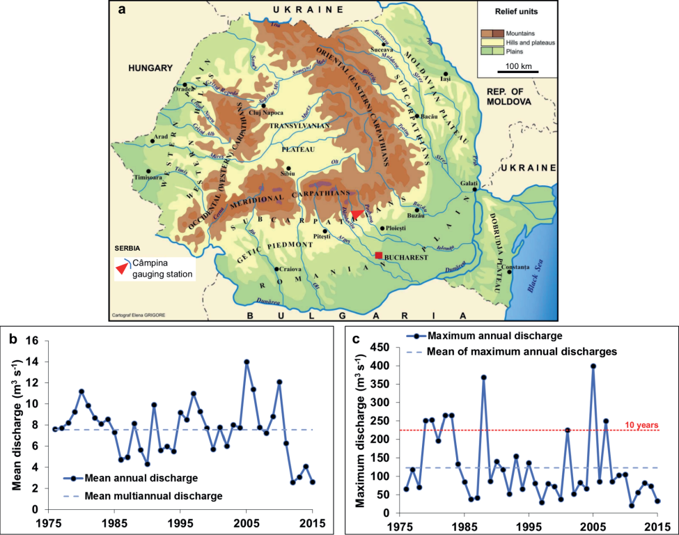
Fig. 1. Study area: a) location in Romania of Campina gauging station on the Prahova River; b) variations (1976-2015) of mean and c) maximum annual discharges of the Prahova River at Campina gauging station (dashed red line indicates the 10 years return period discharge)
During the analyzed time interval, the subcarpathian sector of the Prahova River was affected by fluvial metamorphosis - most of the braided features have been lost, together with significant expansion of vegetation on the banks and erosion of in-stream vegetated islands to the point of disappearance (Ioana-Toroimac et al. 2010; Ioana- Toroimac 2016). The same sector went through a severe incision, up to 5 m in certains sites (Armas et al. 2012). The river has a natural long-term tendency for incision due to geological causes (Armas et al. 2012). It is hazardous to consider the precipitation as responsible for the river incision in this sector, because no statistical trend was detected in the annual amount of precipitation recorded at weather stations in the Upper Prahova catchment (Marin et al. 2014) except for a decreasing trend in summer in the mountains in the last decennies (Dumitrescu et al. 2014). Daily precipitation characterizes by a negative trend of the number of days with heavy rains and of daily intensity, but a positive trend of the number of consecutive dry days (Croitoru et al. 2016). Despite the deduction of a decrease of the pluvial erosivity, some torrents and landslides were reported as active with socio-economical impact in the Carpathians and Subcarpathians, therefore contributing to the river sediment supply (Ioana-Toroimac et al. 2010). Moreover, several morphogenic floods (e.g., return period > 10 years) have temporally reactivated the floodplain (Ioana-Toroimac et al. 2010) despite its overall trend of narrowing. Therefore, we conclude that the anthropic factor is the main driver of fluvial metamorphosis and river incision (Ioana-Toroimac et al. 2010; Armas et al. 2012). An example of channel incision is shown in Fig. 2a and b. Human interventions, such as check dams, bank protection, channel rectification, water intakes, micro power plants, torrential works in the catchment, increasing soil sealing, probably diminished the sediment supply of the river and accelerated the channel incision. The Prahova River channel is one of the most altered by various human pressures in the South-Eastern Subcapathians (Ioana- Toroimac et al. 2017). The high alteration is due mainly to socio-economic stakes in the Prahova upper watershed. In the vicinity of Campina gauging station, the management of fluvial processes and hydrological hazards must also consider the international road E60 on the left bank and the railway and small enterprises (i.e., built area) on the right bank.

Fig. 2. Dynamics of the Prahova river channel at ca. 200 m upstream of Campina gauging station in April 2007 (a) and in November 2017 (b)
To analyse the channel adjustments of the Prahova River, we used cross-section profiles at Campina gauging station. The analysis overlaps the time interval 1976-2015, during which the staff gauge was fixed and represented the landmark used for comparison of all cross-section profiles. The cross-section profiles (randomly chosen 1/year during the studied period) were analysed at the bankfull stage according to the topographic criterion of the lowest bank. The chronological series of cross-section parameters (i.e., depth, width, area, wetted perimeter, hydraulic radius) were analysed by using the non-paramentric test of Mann- Kendall to detect a trend of evolution (α < 0.05) and the non-parametric test of Pettitt (α < 0.05, Pettitt 1979) and the procedure of Hubert (Scheffe 1%, Hubert 2000) to detect a changing point. In order to better understand the vertical dynamics of the riverbed, we analysed the variation of the absolute altitude (in m a.s.l.) of the point of maximum depth (PDmax) for all the available cross-sections during the studied period (approximately 70 values per year during the 40 years of the analysis.) The PDmax was computed for each cross-profile, as difference between the absolute altitude (in m a.s.l.) of the point zero («0») set on the gauging station's staff (this altitude does not change over the years) and «hp oscillation», which expresses the difference between the water stage and the corresponding water maximum depth relative to the point «0» of the gauging station's staff (according to the methodology described by Zaharia et al. 2011).
To characterize the flow of the Prahova River at Campina gauging station, the bankfull discharge was calculated based on the Manning equation (Manning 1889), integrating the cross-section parameters at the bankfull stage, the water slope measured simultaneously with the cross-section and Manning roughness coefficient corresponding to bed material grain size (80% medium, coarse gravel and cobble; 20% fine gravel and sand on the latest cross-section profile). Further, the return period of the bankfull discharge was estimated based on the series of maximum annual discharges (1976-2015) by using the log Pearson type III distribution.
During the analysed period, we found that the Prahova riverbed has been deepening. Thus, the maximum depth of the cross-section recorded a positive trend according to the Mann-Kendall test. The maximum depth increased from 1.3 m in 1976 - min to 3.0 m in 2015 - max (mean = 1.9 m; median = 1.7 m; standard deviation = 0.5 m). The maximum depth registered a changing point in 1998 according to Pettitt test and three segments were identified (1976-1991, 1992-2000, and 2001-2015) according to Hubert procedure (Fig. 3a). The PDmax appears to confirm the negative trend in the variability of the maximum depth of the river channel (Fig. 3b). Overall, the PDmax varied on an amplitude of approximately 3.5 m. The deepest incision between two consecutive cross-section profiles of about - 1.3 m occurred in July 1988 followed a few days later by the highest aggradation of+1.3 m in relation to the second peak of the maximum annual discharges of the period 1976-2015 (Fig. 1c), indicating the new equilibrium of the hydrosystem disturbed by a flood. The overall incision was gradually and the PDmax generally maintained under its mean value after 2001 (Fig. 3b).
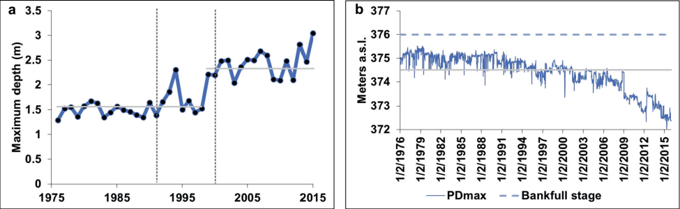
Fig. 3. Variations of channel depth of the Prahova River at Campina gauging station (1976-2015): a) maximum value at the bankfull stage (light grey line indicates the mean value of the two intervals according to Pettitt test and dark grey dashed line indicates the Hubert segments); b) point of maximum depth - PDmax (light grey line indicates mean PDmax)
The cross-section width didn't register a trend in its variability (mean = 44.4 m; median = 44.7 m; standard deviation = 2.6 m). Similarly, the width chronological series had no changing points or segments (Fig. 4a).
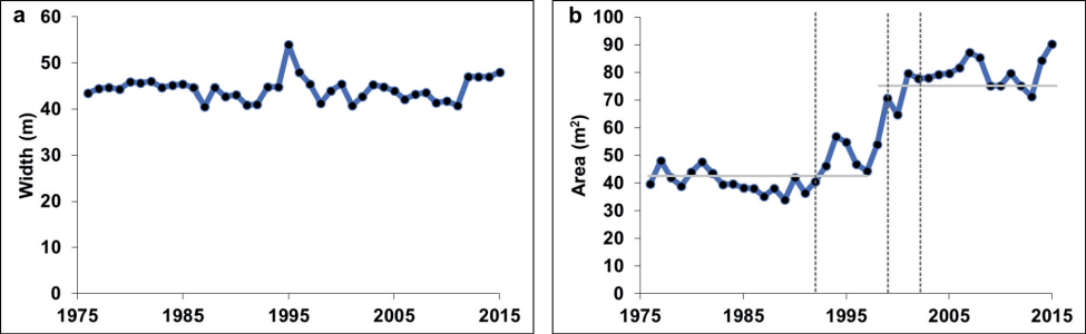
Fig. 4. Variations of a) channel width and b) cross-section area at the bankfull stage of the Prahova River at Campina gauging station (1976-2015, light grey line for the mean value of the two intervals according to Pettitt test and dark grey dashed line for Hubert segments)
The cross-section area had a positive trend during the analysed time interval according to the Mann-Kendall test. The area increased from 39.7 m2 in 1976 to 90.2 m2 in 2015 - max (min = 34.0 m2 in 1989; mean = 58.1 m2; median = 51 m2; standard deviation = 18.8 m2). The cross-section area recorded a changing point in 1997 according to Pettitt test and several segments were identified (i.e. 1976-1992, 19931997, 1998-2000, and 2001-2015), according to Hubert procedure (Fig. 4b).
The wetted perimeter didn't register a trend in its variability (mean = 45.5 m; median = 45.8 m; standard deviation = 2.4 m), with no changing points according to Pettitt test. However, Hubert procedure revealed several segments: 1976-1994, 1995-1996, 1997-2011, and 20122015 (Fig. 5a).
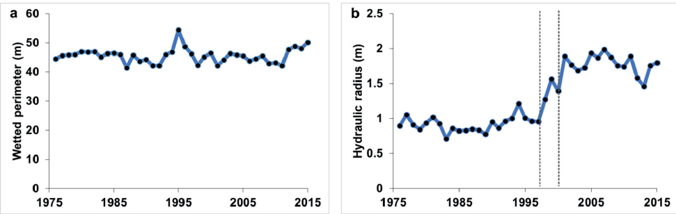
Fig. 5. Variations of a) wetted perimeter and b) hydraulic radius at the bankfull stage of the Prahova River at Campina gauging station (1976-2015, dark grey dashed line for Hubert segments)
The hydraulic radius statistically increased from 0.8 m in 1976 to 1.8 m in 2015 (mean = 1.2 m; median = 1.0 m; standard deviation = 0.4 m). The hydraulic radius time series didn't record a changing point according to Pettitt test, but it is segmented in 1976-1998, 1999-2001, and 2002-2015 according to Hubert procedure (Fig. 5b).
In the morphology of the cross-section of the Prahova River at Campina gauging station, different changes were identified (Fig. 6): increase of the maximum depth between 1991-1992; increase of both cross-section area and maximum depth between 1997-1999; and overall drastic channel incision between 1976-2015.
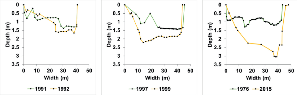
Fig. 6. Variations of the cross-section at the bankfull stage of the Prahova River at Campina gauging station, in different periods
As a consequence of increased channel capacity, during the analysed period, the bankfull discharge increased from 44.9 m3s-1 in 1976 to 163.8 m3s-1 in 2015 (mean = 97.9 m3s- 1; median = 61.1 m3s-1; standard deviation = 65.4 m3s-1). The maximum bankfull discharge occurred in 2007, while the minimum bankfull discharge in 1988 (Fig. 7a).
The return period of the bankfull discharge increased from 1.1 years in 1976 to 5.3 years in 2015. The maximum value of the return period, i.e. 9 years, corresponded to the high bankfull discharge of 2007 (Fig. 7b).
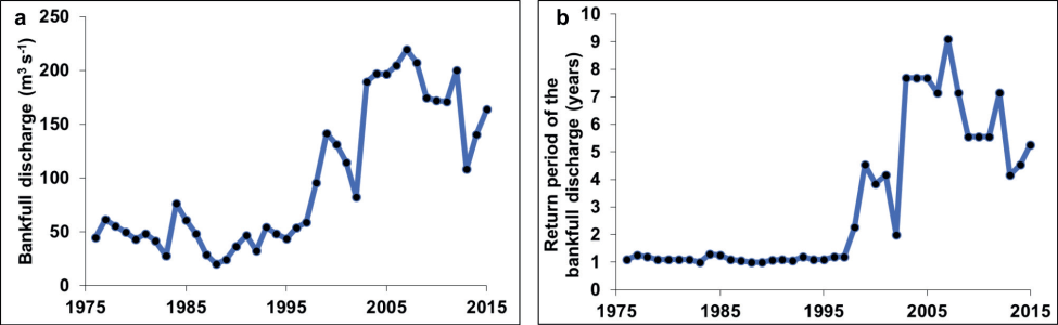
Fig. 7. Variations of a) bankfull discharge and b) associated return period of the Prahova River at Campina gauging station (1976-2015)
The analysis of the Prahova river channel dynamics at Campina gauging station indicated a severe incision of the riverbed and increased channel capacity associated to lateral stability. These processes were followed by a decrease of the probability of flooding over the bankfull discharge.
Our results confirm previous works concerning the incision of the Prahova River in the South-Eastern Subcarpathians (Armas et al. 2012). The magnitude of the incision is probably maximum in the studied area, while the lower course of the Prahova River was not affected by this process according to Ioana-Toroimac et al. (2015). As response to disturbances, major channel adjustments occured in the beginning of 1990s and especially at the end of 1990s. At the beggining of 2000s, the hydrosystem probably relaxed. Since, the hydrosystem preserved the new features, namely channel incision.
The Prahova river channel incision at Campina gauging station should be interpreted as part of the entire hydrosystem functionning: the channel incision appears to be the process following the channel narrowing upstream and downstream (Ioana-Toroimac et al. 2010). The incision isn't followed by banks' collapse due to the relativelly hard rocks constituting the river channel. Therefore the incision can't naturally be attenuated. The river channel pattern dynamics in our case study is relativelly similar to the ones of the Italian rivers described by Surian and Rinaldi (2003).
We can only hypothesise about these disturbances in the Prahova hydrosystem. Finding the precise disturbance responsible for the channel incision, which took place 20 years back, is impossible in lack of detailed registers. We advance the hypothesis of human pressures as no major flood occured in the end of 1990s (Fig. 1c); moreover, the highest flood as dischage in 2005 didn't manifest itself by notable channel adjustments. As example of human pressures, dredging was a common practice in the region to avoid river channel aggradation in the vicinity of bridges (Ioana- Toroimac 2014). Therefore, gravel and sand exploitation from the river channel maintained as frequent practice in Romania (Salit and Ioana-Toroimac 2013). Similarly, anthropic increase of the channel capacity is still seen as a way to protect against floods in Romania (ABAS 2015).
There are numerous gaps in the analysis of channel incision of the Prahova River. In lack of other long-term and precise topographic measurements, data from gauging stations are the most suitable and accurate to quantify the channel incision. However, the low number of crosssection profiles diminishes the precision of the results. The decreasing number of points along a cross-section profile (e.g., 46 points on 43.5 m in 1976 versus 15 points on 48 m in 2015 - Fig. 6) also diminishes their fidelity when compared to the studied section. Other measurements compared to stable landmarks, such as the bankfull stage, should complete the ones associated to hydrological variability. Measuring only the PDmax is incomplete as the cross-section area at the bankfull stage also describes the features of the incision. We recommend to enhance cross-section topographic measurements at gauging stations. We recommend as well to continuously and rigorously monitor and inventory human pressures in order to track back disturbances corresponding to channel adjustments.
The return period of the bankfull discharge of the Prahova River increased especially after 1997 in relation to channel capacity growth: from 1.1 years in 1976 to about 5 years in 2015. The latter value is higher than those in the literature, where the return period of the bankfull discharge is thought to be 1-2 years (Leopold 1954) or 1.58 years (Dury et al. 1963) and similar for the majority of stable channels (Doyle et al. 2007), which confirms Prahova river channel adjustments when compared to a normal situation. To better understand the relation between channel incision and floods, the analysis must be completed by estimating the effective discharge that transports the greatest quantity of sediments (Doyle et al. 2007).
However, the values of the bankfull discharge and return period must be carefully interpreted. As shown in Fig. 7a and b, these values appear to have high variability. They strongly depend on the hydrological variability and more precisely on the water slope. In our estimations, the water slope corresponds to the measurement of a random water stage, which probably is lower than the bankfull stage for safety during field work. Therefore, to gain precision in estimating the bankfull discharge, we recommend to enhance knowledge on water slope by field measurements related to the hydraulics of floods or by hydraulic modelling.
The Prahova River long-term incision and high erosion during floods determined an increase of the channel capacity and return period of the bankfull discharge up to maximum 9 years in the studied section. Additionally, the minimum annual water stages probably decreased with ecological negative effects. As a consequence, the morphogenic floods are less frequent in the floodplain area and the floodplain accretion is expected to take a longer time. The river became largely disconnected from the floodplain, which reduced delivery of organic matter and wood debris from the riparian zone and limited the availability of remnant channels and ponds in the floodplains for river biota (Wyzga et al. 2011). As incision probably increased the velocity of flood flows in the channel and the river competence, floods may be more destructive now for the structures located within the channel (Wyzga et al. 2016b), which is even more intense in the case of a high energy river such as the Prahova River. In our case study, the loss of floodwater storage in the floodplain area doesn't imply the increase in flood hazard to downstream river sector as the braided river channel becomes very large (up to 300 m according to Ioana-Toroimac 2016) and takes over the capacity to stock floodwater.
As river management practice, Fig. 2a and b shows concrete bank protection structures on the right side built up before 2007 against lateral erosion. Between 2007-2017, a low-invasive rectification was set up (i.e., raise of an instream alluvial bar) to deviate the main flow from the right bank. Further field investigations revealed that, after 2015, the left bank of the Prahova River at Campina gauging station was protected against lateral erosion by gabions. Hypothetically, the bank stabilisation works further increase the incision (Galia et al. 2015). Therefore, we conclude that river management maintains channel incision in the studied area.
The channel incision of the Prahova River at Campina gauging station reduce the frequency of river overflowing, therefore mitigate the flood risk in the studied area. This solution appears to be preferred by river managers probably for socio-economic purposes. Future transdisciplinary studies must analyse the sustainability of this solution.
This paper showed that the impact of channel incision on floods is translated by an increase of the bankfull discharge and of its return period. In the case of the Prahova River at Campina gauging station, during 1976-2015, the total incision was of 1.7 m of maximum depth and the channel capacity doubled. Between the two extreme years of the analysed time interval (1976 and 2015), the bankfull discharge raised from 44.9 m3s-1 to 163.8 m3s-1, and the associate return periods increased from 1.1 years to 5.3 years. However, these values are oscillating, depending on the dominant fluvial process associated to the hydrological variability. The values also depend on the accuracy of field measurements, which should be a major concern for river managers.
As implications for river management, overflowing became less frequent while floods probably became more competent and destructive in the channel. As no measure was taken so far to diminish the Prahova river channel incision, the situation may be considered worthwhile for flood risk management in the studied area, and should be taken into consideration for river basin planning in the context of the EU-WFD. Future transdisciplinary studies are needed to reveal the sustainability of this solution.
1. ABAS (Administrația Bazinală de Ape Siret) (2015). Planul de management al riscului la inundații. București: Administrația Națională Apele Române.
2. Armaş I., Gogoaşe Nistoran D.E., Osaci-Costache G. and Braşoveanu L. (2012). Morphodynamic evolution patterns of Subcarpathian Prahova River (Romania). Catena, 100, 83-99, DOI: 10.1016/j.catena.2012.07.007.
3. AQUAPROIECT (1992). Atlasul Cadastrului apelor din România. Bucureşti: Ministerul Mediului.
4. Beechie T.J., Pollock M.M. and Baker S. (2008). Channel incision, evolution and potential recovery in the Walla Walla and Tucannon River basins, northwestern USA. Earth Surface Processes and Landforms, 33, 784-800, DOI: 10.1002/esp.1578.
5. Chiriloaei F., Rădoane M., Perşoiu I. and Popa I. (2012). Late Holocene history of the Moldova River Valley, Romania. Catena, 93, 64-77, DOI:10.1016/j.catena.2012.01.008.
6. Croitoru A.E., Piticar A. and Burada D.C. (2016). Changes in precipitation extremes in Romania. Quaternary International, 415, 325-335, DOI: 10.1016/j.quaint.2015.07.028.
7. Doyle M.W., Shields D., Boyd K.F., Skidmore P.B. and DeWitt D. (2007). Channel-forming discharge selection in river restoration design. Journal of Hydraulic Engineering, 831-837, DOI: 10.1061/(ASCE)0733-9429(2007)133:7(831).
8. Dumitrescu A., Bojariu R., Birsan M.V., Marin L. and Manea A. (2014). Recent climatic changes in Romania from observational data (19612013). Theoretical and Applied Climatology, DOI: 10.1007/s00704-014-1290-0.
9. Dury G.H., Hails J.R. and Robbie H.B. (1963). Bankfull discharge and magnitude-frequency series. Australian Journal of Science, 26, 123-124.
10. European Commission (2000). Directive 2000/60/EC—establishing a framework for community action in the field of water policy. Official Journal of European Communities, 327.
11. Galia T., Hradechý J. and Škarpich V. (2015) Sediment transport in headwater streams of the Carpathian flysch belt: its nature and recent effects of human interventions. In: P. Heininger, J., Cullmann, eds., Sediments matters. Cham: Springer, 13-26, DOI: 10.1007/978-3-319-146966_2.
12. Gilbert R.O. (1987). Statistical methods for environmental pollution monitoring. New York: Wiley.
13. Haase P., Hering D., Jähnig S.C., Lorenz A.W. and Sundermann A. (2013). The impact of hydromorphological restoration on river ecological status: a comparison of fish, benthic invertebrates, and macrophytes. Hydrobiologia, 704, 475-488, DOI:10.1007/s10750-012-1255-1.
14. Hajdukiewicz H., Wyżga H. and Zawiejska J. (2019). Twentieth-century hydromorphological degradation of Polish Carpathian rivers. Quaternary International, 504, 181-194, DOI:10.1016/j.quaint.2017.12.011.
15. Hubert P. (2000). The segmentation procedure as a tool for discrete modeling of hydrometeorological regimes. Stochastic Environmental Research and Risk Assessment, 14, 297-304, DOI: 10.1007/PL00013450
16. Ioana-Toroimac G. (2014). La dynamique hydro-géomorphologique de la rivière Prahova: fonctionnement actuel, évolution récente et conséquences géographiques. București: Editura Universitară.
17. Ioana-Toroimac G. (2016). Inventory of long-term braiding activity at a regional scale as a tool for detecting alterations to a rivers’ hydromorphological state: a case study for Romania’s South-Eastern Subcapathians. Environmental Management, 58, 1, 93-106, DOI: 10.1007/s00267-016-0701-7.
18. Ioana-Toroimac G., Dobre R., Grecu F. and Zaharia L. (2010). Evolution 2D de la bande active de la Haute Prahova (Roumanie) durant les 150 dernières années. Géomorphologie: relief, processus, environnement, 3, 275-286, DOI: 10.4000/geomorphologie.7988.
19. Ioana-Toroimac G., Minea G., Zaharia L., Zarea R. and Borcan M. (2013). Hydrogeomorphological river typology in the Ialomița and Buzău catchments (Romania). In: G. Arnaud-Fassetta, E. Masson, E. Reynard, eds., European Continental Hydrosystems under Changing Water Policy. München: Verlag Dr. Friedrich Pfeil, 261-272.
20. Ioana-Toroimac G., Zaharia L. and Minea G. (2015). Using pressure and alteration indicators to assess river morphological quality: case study of the Prahova River (Romania). Water, 7, 2971-2989, DOI: 10.3390/w7062971.
21. Ioana-Toroimac G., Zaharia L., Minea G. and Moroșanu G.A. (2017). Using a multi-criteria analysis to identify rivers with hydromorphological restoration priority: braided rivers in the south-eastern Subcarpathians (Romania). Science of the Total Environment, 599-600, 700-709, DOI:10.1016/j.scitotenv.2017.04.209.
22. Karthe D., Chifflard P. and Büche T. (2018). Hydrogeography – linking water resources and their management to physical and anthropogenic catchment processes. Die Erde 149, 2-3, 57-63, DOI: 10.12854/erde-2018-412.
23. Kendall M.G. (1975). Rank correlation methods. London: Charles Griffin.
24. Korpak J. (2007). The influence of river training on mountain channel changes (Polish Carpathian Mountains). Geomorphology, 92(3-4), 166-181, DOI: 10.1016/j.geomorph.2006.07.037.
25. Krengel F., Bernhofer C., Chalov S., Efimov V., Efimova L., Gorbachova L., Habel M., Helm B., Kruhlov I., Nabyvanets Y., Osadcha N., Osadchyi V., Pluntke T., Reeh T., Terskii P. and Karthe D. (2018). Challenges for transboundary river management in Eastern Europe – three case studies. Die Erde, 149, 2-3, 157-172, 101-116, DOI:10.12854/erde-2018-389.
26. Landon N., Piégay H. and Bravard J.P. (1998). The Drôme River incision (France): from assessment to management. Landscape and Urban Planning, 43, 119-131.
27. Leopold L.B. (1954). Determination of hydraulic elements of rivers by indirect methods. United States Government Printing Office: Geological Survey Professional.
28. Mann H.B. (1945) Non-parametric tests against trend. Econometrica 13,163-171.
29. Manning R. (1889). On the flow of water in open channels and pipes. Trans. Institution of Civil Engineers of Ireland, 20 161-166.
30. Marin L., Birsan M.V., Bojariu R., Dumitrescu A., Micu D.M., and Manea A. (2014). An overview of annual climatic changes in Romania: trends in air temperature, precipitation, sunshine hours, cloud cover, relative humidity and wind speed during the 1961–2013 period. Carpathian Journal of Earth and Environmental Sciences, 9, 4, 253-258.
31. Pettitt A.N. (1979). A Non-Parametric Approach to the Change-Point Problem. Journal of the Royal Statistical Society. Series C (Applied Statistics), 28, 2, 26-135, DOI: 10.2307/2346729.
32. Rădoane M., Obreja F., Cristea I. and Mihăilă I. (2013). Changes in the channel-bed level of the eastern Carpathians rivers: climatic vs. human control over the last 50 years. Geomorphology, 193, 91-111, DOI: 10.1016/j.geomorph.2013.04.008.
33. Richter S., Völker J., Borchardt D. and Mohaupt V. (2013). The Water Framework Directive as an approach for Integrated Water Resources Management: results from the experiences in Germany on implementation, and future perspectives. Environmental Earth Sciences, 69, 719728, DOI: 10.1007/s12665-013-2399-7.
34. Salit F. and Ioana-Toroimac G. (2013). Actual in-stream mining in alluvial rivers: geomorphological impact and European legislation, 3rd International Geography symposium GEOMED, Symposium Proceedings – Kemel (Antalya)/Turkey (June, 10th-13th 2013), 201-210.
35. Stähly S., Franca M. J., Robinson C.T. and Schleiss A.J. (2019). Sediment replenishment combined with an artificial flood improves river habitats downstream of a dam. Scientific Reports, 9, 5176, DOI: 10.1038/s41598-019-41575-6.
36. Surian N. and Rinaldi M. (2003) Morphological response to river engineering and management in alluvial channels in Italy. Geomorphology, 50, 307-326, DOI: 10.1016/S0169-555X(02)00219-2.
37. Wyżga B., Oglẹcki P., Radecki-Pawlik A. and Zawiejsa J. (2011). Diversity of macroinvertebrate communities as a reflection of habitat heterogeneity in a mountain river subjected to variable human impacts. In: A. Simon, S.J. Bennett, J.M. Castro, eds., Stream restoration in dynamic fluvial systems. Scientific approaches, analyses, and tools. American Geophysical Union.
38. Wyzga B., Zawiejska J., Radecki-Pawlik A. and Hajdukiewicz H. (2012). Environmental change, hydromorphological reference conditions and the restoration of Polish Carpathian Rivers. Earth Surface Processes Landforms, 37, 1213-1226, DOI: 10.1002/esp.3273.
39. Wyzga B., Zawiejska J. and Hajdukiewicz H. (2016a). Multi-threat rivers in the Polish Carpathians: occurrence, decline and possibilities of restoration. Quaternary International 415, 344-356, DOI: 10.1016/j.quaint.2015.05.015.
40. Wyżga B., Zawiejska J. and Radecki-Pawlik A. (2016b). Impact of channel incision on the hydraulics of flood flows: Examples from Polish Carpathian rivers. Geomorphology, 272, 10-20, DOI: 10.1016/j.geomorph.2015.05.017.
41. Wyżga B., Kundzewicz Z.W., Konieczny R., Piniewski M., Zawiejska J. and Radecki-Pawlik A. (2018). Comprehensive approach to the reduction of riverflood risk: Case study of the Upper Vistula Basin. Science of the Total Environment, 631-632, 1251-1267, DOI: 10.1016/j.scitotenv.2018.03.015.
42. Zaharia L., Grecu F., Ioana-Toroimac G. and Neculau G. (2011). Sediment transport and river channel dynamics in Romania – variability and control factors. In A.J. Manning, ed., Sediment transport in aquatic environments. Rijeka: INTECH, 293-316.
43. Zaharia L., Costache R., Prăvălie R. and Ioana-Toroimac G. (2017). Mapping flood and flooding potential indices: a methodological approach to identifyng areas susceptible to flood and flooding risk. Case study: the Prahova catchment (Romania). Frontiers of Earth Sciences, 11, 2, 229-247, DOI: 10.1007/s11707-017-0636-1.
Faculty of Geography
1 Nicolae Bălcescu, 010041, Bucharest
Faculty of Geography
1 Nicolae Bălcescu, 010041, Bucharest
97E Șos. București-Ploiești, 013686, Bucharest
97E Șos. București-Ploiești, 013686, Bucharest
Ioana-Toroimac G., Zaharia L., Neculau G., Minea G. Impact Of Channel Incision On Floods: A Case Study In The South-Eastern Subcarpathians (Romania). GEOGRAPHY, ENVIRONMENT, SUSTAINABILITY. 2020;13(2):17-24. https://doi.org/10.24057/2071-9388-2019-177

Editor-in-Chief
Kasimov Nikolay S.Lomonosov Moscow State University
Moscow 119991 Russia, Leninskie Gory, Faculty of Geography, 1806a
Phone +7 495 939-15-52
E-mail: ges-journal@geogr.msu.ru


