


Contents
Scroll to:
https://doi.org/10.24057/2071-9388-2019-76
Scroll to:
Dirin D.A., Fryer P. The Sayan borderlands: Tuva’s ethnocultural landscapes in changing natural and sociocultural environments. GEOGRAPHY, ENVIRONMENT, SUSTAINABILITY. 2020;13(1):29-36. https://doi.org/10.24057/2071-9388-2019-76
Tuva is a border region not only in geopolitical terms, neighbouring Mongolia and near China's restless Xinjiang, but also in natural and cultural senses at the global scale. In natural terms, the Sayan Mountains of Tuva are part of the Eurasian climatic zone and watershed. Their rivers feed the Arctic water basin and form the boundary between the Siberian taiga and steppes and semi-deserts of Inner Asia. Moreover, Tuva is situated at the nexus of three cultures (civilisations): the Christian-Slavonic industrial-agricultural world (European Russia), the Turkic-Finno-Ugrian animistic forest world (Siberia) and the Turkic-Mongol Buddhist- Islamic nomadic world (Inner Asia). At the same time, in Tuva different ethnocultural traditions have been maintained, which has continued to produce specific ethnocultural landscapes.
The term 'ethnocultural landscape' (ECL) is understood as a natural-cultural territorial complex, formed because of the evolutionary interaction of nature with the local ethnic community, practically, semantically and symbolically developing and transforming geographical space according to its spiritual and material needs. An important feature of the ethnocultural landscape is the interpenetration of the ethnic culture into the surrounding space and this space into the ethnic culture. The study of these processes of ethnic groups' interaction with their geographic environments has been very important in geography, ethnology, anthropology, and other fields.
The ethnic history and culture of Tuva has long attracted the attention of researchers, but the aim of this study is to identify patterns in the formation, functioning and development of ethnocultural landscapes in the Republic of Tuva, which has not been undertaken before. This research on the ethnocultural landscapes of Tuva involves analysing the key factors in their formation, establishing the patterns of spatial and functional organisation, and identifying the important causes of and trends in the current situation.
At the beginning of the 20th century, at the meeting point of geography, cultural studies and ethnography (ethnology), almost simultaneously in Russia (Berg 1915), Germany (SchlQter 1920) and the USA (Sauer 1925) the concept of cultural landscape began to develop. The research focus was the 'cultural landscape' as a natural-social system in which all components (human community, its economy, the natural environment, elements of material and spiritual culture, etc.) inextricably are linked and interdependent; the resulting cultural landscapes themselves are due to this interaction of society and nature. Thus, the main properties of cultural landscapes are their consistency and spatial character (territorial localisation). At the same time, besides a community's purely practical material relations with the natural environment, spiritual relations with cultural landscapes are considered.
Within the framework of this concept, the idea of the ethno-historical essence of the cultural landscape appeared quite quickly (e.g., Lowenthal et al. 1965; Hayrynen 1994; Kalutskov 1998; Yamskov 2003, etc.). Developing out of this idea, an 'ethnocultural approach' to the study of cultural landscapes emerged, which within a short time became one of the most recognised and developed in Russian geographical study. The focus of this approach is the spatial expression of the culture of an ethnic group - an ethnocultural landscape. Viewing the development of an ethnic group through the prism of the ethnocultural landscape is, in fact, borrowing the commonly used landscape indication method from natural science in cultural geography. The most famous proponent of the ethnocultural landscape concept in cultural geography is V.N. Kalutskov. Importantly, his efforts have formed the theoretical and methodological basis of modern ethnocultural landscape research (e.g., Kalutskov, Ivanova and Davydova 1998; Kalutskov 2008; 2011). Additionally, theoretical and applied research in the field of ethnocultural landscapes has been conducted by A.N. Yamskov, T.M. Krasovskaya, V.V. Kuklina, A.V. Lysenko, Zh.F. Degteva, and D.A. Dirin.
Ethnocultural landscape research is profoundly orientated towards field research, resulting in the use of methodologies of related disciplines, such as ethnography, ethno-linguistics, toponymy, folklore studies, etc. Most often, the ethnocultural landscape approach is used in areas with compact populations of ethnic or sub-ethnic groups - especially if they are characterised by a traditional way of life - as well as in multi-ethnic territories. It is not by chance that ethnocultural landscapes are actively examined in the Russian North (Kalutskov 1998b; 2005), the Russian Far North (Klokov, Krasovskaya and Yamskov 2002; Krasovskaya 2012), Sakha-Yakutia (Degteva 2017), south Siberia (Kuklina 2006; Dirin 2008; 2011; 2014) and the Caucasus (Lysenko 2009; Salpagarova 2003).
Outside of Russia, this approach has not yet become widespread. The concept of 'ethnic landscape' as adopted by Anglo-American cultural geography (e.g., Lehr 1990; Noble 1992; Cross 2017) is not identical to the Russian geographical concept of 'ethnocultural landscape'. The ethnic landscape appears as a purely humanitarian-geographical concept - localised ethnic groups in their space with an emphasis on the social characteristics of the community itself, but with largely a complete disregard for nature in the cultural landscape.
Several methods and sources of empirical materials are utilised in this study. To identify the key factors in the ethnocultural development of Tuva, an extensive literature review was conducted on the natural features of the territory and their historical dynamics, settlement history, natural resource management, cultural development, the interaction of indigenous Tuvans with other peoples, and political transformations, especially those influencing the republic's economy and culture. Additionally, an analysis of historical maps was made to follow the dynamics of territorial organisation.
A study of the territorial and functional organisation of Tuva results in the delimitation of boundaries between various ethnocultural landscapes, but also identifies common and specific features in their functioning and connections between them. Maps (cartographic methods) with various themes have also been analysed to delimit the ethnocultural landscapes of Tuva, often used in conjunction with one another: physical maps indicating physiographic boundaries, including watersheds, landscape types, altitudinal belts, climatic zones, etc.; ethnic maps highlighting areas of settlement, sub-ethnic groups, ethnic contact zones; economic maps, including natural resource management systems of various types; religious maps of main confessions, important centres and peripheries; political maps with administrative boundaries and centers); cultural-historical maps showing historical boundaries and places of historical memory; toponymic-linguistic maps identifying language distribution, dialects and marking the geocultural space through geographical names that suggest a relationship to a particular ethnocultural community; mental maps reflecting local perceptions of a territory, as well as the location of ethnocultural boundaries. Geoinformatics (GIS) are used to represent the ethnocultural landscapes cartographically and to model the spatial processes. An ArcGIS research database was created and information recorded in GIS attribute tables is displayed in the form of map layers.
A comprehensive study of modern ethnocultural landscapes cannot be achieved without the use of statistical data. The analysis of regional statistical information was conducted, reflecting the spatial organisation of the population and economy, the sectoral structure of the economy, as well as their dynamics. The toolkit of the Statistica software package was used to perform calculations. To determine historical patterns and trends, a statistical analysis of significant indicators from the perspective of cultural and geographical processes was made to identify changes. The key sources of statistical data are the regional statistical body (http://krasstat.gks.ru/wps/wcm/connect/rosstat_ts/krasstat/ru/statistics/tuvStat/) and the Unified Interdepartmental Information and Statistical System 'State Statistics' (https://fedstat.ru/).
Fieldwork, which involved, in addition to observation, the use of sociological methods (questionnaires, interviews), also was employed. During expeditionary fieldwork in Tuva from 2014 to 2018, modern ways of adaptation by different ethnoterritorial populations to different types of landscapes was observed; the regime of daily and periodic household activities related to the functioning of ethnocultural landscapes. Questionnaires were administered to local communities to identify the main features of the spatial and functional organisation of today's ethnocultural landscapes, as well as to isolate important trends. A total of 382 people took part in the survey, living in 23 settlements (including temporary ones) in the republic. Moreover, 32 interviews with representatives from different ethno-territorial, gender, age and social groups provided additional details on ethnocultural landscape development that were not evident from the results of the survey.
The factors that determined the modern mosaic of ethnocultural landscapes of Tuva are numerous and varied. They include the natural features of the territory and processes of social development. For each historical period, different processes and phenomena had greater influence in ethnocultural developments. However, the key factors that ensured the formation of the characteristics of the varying ethnocultural landscapes that currently exist in Tuva can be identified.
Geocultural permeability: A system of mountain ranges covers the territory of Tuva, with uplands and large intermontane basins. At the same time, the general regularity of the relief structure is such that from the west and north Tuva is limited by the high mountains of the Altai and the Western and Eastern Sayans, while in the south and
the east there are the much lower ranges of the Western and Eastern Tannu-Ola mountains, the Sangheli Highlands, and the Ubsunur Hollow. Thus, the territory of Tuva historically is rather strongly isolated from cultural influences from the north and north-west - Christian-Slavonic industrial- agricultural world (European Russia) and Turkic-Finno-Ugrian animistic forest world (Siberia). At the same time, Tuva is open to influence from the south and the Turkic-Mongol Buddhist- Islamic nomadic cultures of Inner Asia. Due to this natural factor, Tuva is historically and culturally the peripheral part of Inner Asia, not Siberia. The centuries-old close relationship of the Tuvan population with other nations of the Great Steppe predetermined the commonality of their material and spiritual culture, especially in terms of activities, everyday life, folklore, prevailing religious views, common behaviours, etc. The isolation of Tuva as a part of Inner Asia from other cultural worlds, especially the Russian and Chinese, impeded cultural diffusion, while maintaining originality in local cultures; there was a socio-economic lag compared to more open territories. Although important, this isolation was not absolute. The development of transport infrastructure, scientific and technical progress, changing socio-economic conditions, and historical and political processes made the mountain barriers more permeable to cultural diffusion, as well as allowing for migrating ethnocultural communities.
Landscape economy: The economy serves as the foundation for cultural formation and development. It is the economy that provides an economic basis for human existence, as well as the conditions for social stratification, traditions, folklore and much more. Economic activity is also a key factor in the spatial organisation of ethnocultural landscapes, dividing them into functional zones, etc. (Salpagarova, Chomaeva and Uzdenova 2014). In the preindustrial era, the economy was formed almost exclusively by environmental management. Accordingly, the economy depends entirely on the natural resource potential of the territory. Thus, one of the key factors in the formation and development of the ethnocultural landscapes of Tuva, indirectly through natural resource management, was natural landscapes. The landscape structure of Tuva is dominated by steppe and semi-arid steppe landscapes (about 40% of the total area of the republic) and mountainous taiga forests of different subtypes (about 50% of the territory). The upper relief is occupied by subalpine meadows and woodlands, alpine meadow-tundra landscapes, and mountainous uplands.
The presence of large tracts of steppe landscapes contributed to the spread of nomadic and semi-nomadic animal husbandry in Tuva. Sheep, goats and horses traditionally dominate, though yaks and camels also are bred in some parts of Tuva. Since the nineteenth century cattle breeding has spread. Hunting has always been of utmost importance. In the mountainous taiga landscapes of the north-east of Tuva, perhaps influenced by the Tofalars of southern Siberia, the environmental management system of Tozhu Tuvans, who are hunter-gatherers and reindeer herders, has been formed. The gentle topography of large intermontane basins along with and chernozem and chestnut soils drew Russian settlers at the end of the nineteenth - turn of the twentieth centuries. Agriculture was introduced to Tuva, albeit at a small scale. In general, the high altitudes of the landscape structure determine the complexity and differentiation of the economy (Traditional knowledge 2009).
Migration and innovation diffusion: Migrants, when occupying a new territory, create a new ethnocultural landscape for themselves, which reflects the specifics of the spiritual and material culture of the immigrant community, formed in another territory, and new features that result from adaptation to the new natural conditions and borrowings from the indigenous population. At the same time, the immigrants themselves are carriers of innovations that may be adopted by the local population, influencing the established ethnocultural landscapes.
From the nineteenth century Russians began to settle Tuva, the first being Old Believers seeking isolation and sanctuary from religious persecution by the Russian authorities. According to some sources, isolated settlements of Old Believers appeared already in the eighteenth century (Storozhenko 2004). Old Believers were able to adapt farming to local conditions, cultivating rye, oats, potatoes and some other crops, though playing a minor role in their traditional economy. Their economic basis was cattle breeding and forestry, and later included red deer (Siberian Maral) breeding. The majority of Old Believers settled in the taiga, along the Ka-Khem (Little Yenisei) river. From the late 1830s, Russian goldminers began to move to Tuva, founding prospecting settlements on the Sastyg-Khem, Serlig, and Seskier rivers, while in the 1870s the first Russian trading posts were established in Shagonar and Chaa-Khol. These formed very specific ethnocultural mining and industrial landscapes, new to this territory. The intensive migration of landless Russian peasants to Tuva began after 1885. The first Russian agricultural settlements were founded in Turan, Uyuk, and Tarlyk. However, the peak of migration was reached in the years of the Stolypin reform, which coincided with the establishment of a Russian protectorate over Tuva (Bumbazhay 1999). The first Russian villages emerged in Tandinsky kozhuun ('district', Upper Nikolikoye, Nizhneenikolskoye, Sosnovka, Atamanovka) and in Ka-Khem kozhuun (Fedorovka, Boyarovka, Znamenka, Gryaznukha, etc.). By 1917, about 9 thousand Russians lived in Tuva, which accounted for 15% of the population (Pavlova 2013).
The local population borrowed from the Russians, in addition to certain activities (for example, hay harvesting) and tools (agricultural and hunting equipment), entire branches of natural resource management (for example, fishing and beekeeping). Cultural diffusion is not always associated with migration and innovations can be introduced into local culture as a result of trade or military contacts with other nations, missionary activity, etc. This is perhaps how Buddhism arrived in Tuva, occuping an important place in the spiritual and material culture ofTuvans. Buddhist religious sites (stupas, temples), along with the surviving attributes of shamanism (obo cairns, sacred trees, shamanistic groves) and later Orthodoxy (churches, graveyards, roadside crosses) are not only elements in the functional structuring of space - representing a kind of saced zone - but also important markers of 'belonging' in ethnocultural landscapes.
State administration of territory: The influence of state power on the transformation of existing and the emerging ethnocultural landscapes is very strong. After the incorporation of Tuva into the USSR in 1944, its socialist reorganisation quickly unfolded. The abolition of private ownership of land and the formation of large enterprises (collective and state farms), the sedentarisation ofTuvans, the industrial development of mineral and forest resources, the growth of urban settlements, the persecution of religion and the introduction of the ideology of dialectical materialism all became features of the Soviet era that radically changed the region's ethnocultural landscapes and created new ones - industrial-urban, mining, forestry. The symbolism of space changed. In place of 'archaic' symbols of a religious nature, came the symbols of socialism — red flags, steles, monuments and memorials.
Ethnocultural landscapes are hierarchical systems. Therefore, they can be considered at several levels: neighbourhood, local, subregional, regional, interregional. To fully characterise the components of a territory's ethnocultural landscapes, above all else it is necessary to delimit them; that is, to determine their position in space and fix their boundaries. In this study, the delimitation and characterisation of Tuva's ethnocultural landscapes at the regional level was carried out. As outlined above, key factors of geocultural differentiation that determine the isolation of ethnocultural landscapes and can be reflected on maps include natural, ethnic, economic, religious, political- administrative, cultural and historical, toponymic-linguistic, and mental factors.
When identifying individual ethnocultural landscapes at the regional level and delineating their boundaries, all the above factors of geocultural differentiation were analysed. Taking into consideration the various mutually overlapping frontiers, as well as centre-peripheral links, 13 ethnocultural landscapes were identified on the territory of Tuva at the regional level (Fig. 1).
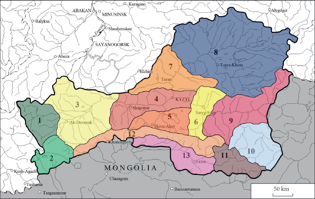
Fig. 1. Ethnocultural landscapes of Tuva (regional level)
*Numbers refer to corresponding individual ethnocultural landscapes in the text.
Each ethnocultural landscape has developed uniquely, however today it is possible to discuss some common factors and development patterns in Tuva beginning from the postSoviet period - from 1991 to the present.
Natural factors: Nature's dynamics change the conditions and effectiveness of economic activity. It requires adaptation, which can be expressed in new methods and technologies of environmental management, or changes in the specialisation or mode of activity.
The most dynamic component of the natural environment is climate. In ethnocultural landscapes, climatic changes are manifested indirectly, through environmental- economic grounds and their characteristics such as biological productivity, resistance, species composition of biota, etc. The warming of our climate is the main change in the natural environment in recent decades. Since 1990, the average January temperature in different parts of the Altai- Sayan highlands has increased by 1.5-4.0°C, and in July by 0.5-2.2°C. At the same time, especially meaningful changes are typical in the intermontane basins - Todzhinskaya, Tuvinskaya, Ubsunurskaya - ofTuva with a severe continental climate (Izmenenie klimata 2011). The area of glaciation and ice mass in the mountain glaciers of Tuva has decreased sharply (Chistyakov, Ganyushkin and Kurochkin 2015). Due to the more intensive melting of glaciers, some rivers drastically have increased runoff, while others have reduced in those basins where there are almost no glaciers. In these processes, the potential for conflict between land users is set, since the availability of water sources is the most important condition for the traditional management of livestock. The degradation of permafrost is activating geomorphological processes, primarily erosion, which affects the territorial infrastructure and the everyday activities of the population, changing the appearance of ethnocultural landscapes. Numerous thermokarst lakes are being formed, which in some areas is the basis for the development of a new branch of economic specialisation - fish farming. Freezing processes are activated in winter, limiting the functioning of the transport system, etc. Weather events have become very unstable: thaws are often replaced by frosts and droughts recur with greater frequency. The transformation of the landscape structure is manifested in the gradual transformation of its species composition, replacing some ecosystems with others and changing the relationships between types (Izmenenie klimata 2011). Many respondents in forested areas of Tuva noted one of the serious problems is the regular scorching of hayfields in the summer due to the absence of rains, which decreases winter fodder, forcing farmers to buy hay that makes livestock farming (especially cattle breeding) unprofitable and decreases herd size.
In internal regions of the territory under consideration (especially in the intermontane basins of Tuva), aridisation of landscapes is even more pronounced. Desertification is occurring, leading to a decrease in the biological productivity of environmental complexes and a decrease in their resistance to anthropogenic impact, pasture degradation, and a reduction in livestock. At the same time, the reduction in the thickness of snow cover even in the forest-steppe medium-size mountains is permitting year-round grazing. Accordingly, over a significant part of the territory under consideration, grasslands gradually are being converted into pastures. Frequent summer droughts and dry winds lead to a reduction in the cultivated area and a degradation of agriculture, reduced mainly to fodder production. In general, the unpredictability of climate processes is creating great risks in economic activity, reflected in the everyday culture, behaviour, and perceptions of the population. According to the results of the survey, the rapidly changing natural environment is one of the most important reasons for people to move out of mountain villages and/ or change traditional activities to others that are less dependent on nature.
Socio-economic factors: The collapse of the Soviet Union at the end of the twentieth century provoked global geopolitical, socio-economic and geocultural transformations around the world. As Tuva represents a periphery in the borderlands, these processes had particularly catastrophic consequences. Most large enterprises have ceased to exist, while the abolition of collective and state farms was promoted by post-Soviet legislative changes (in particular, the return of the right of private enterprise) and the land reform, which permitted private land rental or ownership. In addition, the distribution of land and property shares among former employees of collective farms was of great importance. As a result, many landowners appeared who did not have the material means to conduct a profitable business. Gradually, a return to extensive, but low-cost and inherently traditional forms of enterprise began. The owners of land shares and small herds of cattle began to unite into public (often family-tribal) brigades for joint economic activities. Also, under market conditions and the breakdown of the USSR's internal economy, numerous industrial enterprises went bankrupt, including such giants as the Tuva-Cobalt industrial complex in Khovu-Aksy village. To a large extent, the bankruptcy of basic enterprises and the degradation of the social infrastructure contributed to the outflow of the ethnic Russian population from the republic. Accordingly, many ethnocultural landscapes transformed that 30-40 years ago were 'Russian'.
Additionally, in Tuva new forms of environmental management, which were previously not present, are appearing. For example, a tourism and recreational sector has begun to develop. Numerous fishing, ecological and ethnographic tours are being promoted on the tourist portal of the republic. A part of the Great Sayan Ring branded route passes through the territory of Tuva. While the flow of tourists is insignificant now, its projected increase will make it one of the leading factors in the transformation of traditional ethnocultural landscapes. The development of tourism, in addition to improvements in the socio-economic conditions of the region, is greatly changing the outlook of the local population. Material and mental cultural diffusions gradually are transforming the traditional consciousness of the highlanders. This is manifested in the growth of materialistic and consumer attitudes towards the natural environment and the penetration of elements of popular culture into traditional ethnocultural landscapes (Dirin and Golyadkina 2016).
Geopolitical and geoeconomic shifts in the global and macro-regional order also have a significant transforming effect on the ethnocultural landscapes. After the collapse of the USSR, China became remarkably strong both economically and geopolitically. It should not be forgotten that until 1914 Tuva was a part of China, which until 1944 did not recognise its separation. Therefore, the growing power of China again can be used to incorporate Tuva into its orbit of influence. Vectors of interstate co-operation between Russia, China and Mongolia (the latter performing a buffer function between Russian Tuva and Chinese Xinjiang) are fully capable of defining the role of this region as a territory of active cross-border co-operation or as a border outpost on the edge of the country. Tuva falls within the scope of globally-important socio-economic development projects. Of note is the proposal to construct the Kuragino - Kyzyl - Elegest railway with a further extension to Urumqi via western Mongolia. The implementation of this project would allow linking 'two mainland transport bridges' - the Trans-Siberian Railway and the so-called Eurasian Railway (Shanghai - Beijing - Urumqi - Almaty - Osh and further through Uzbekistan, Turkmenistan, Iran, Turkey, Oman and Qatar, and via another branch through Moscow to Europe). This meets China's development strategy for its western territories, as well as supports the Great Silk Road project. Improving the transport accessibility of the territory of Tuva and its inclusion in the system of trade flows on a global scale can significantly alter the geocultural image of the republic.
Modern ethnocultural landscapes of Tuva are embodied in space as a result of the ongoing process of ethnocultural development, due to the many interrelated factors of a natural, socio-economic and socio-psychological nature, the combination of which is unique for each specific ethnic area. Their study faces many difficulties, as it is necessary to analyse the effect of many natural and social factors that are of mutual influence. Yet ethnocultural landscape research is necessary not only to preserve ethnocultural diversity and the heritage of the material and spiritual culture of ethnic groups, but also to provide an opportunity to optimise the management of a territory's development, minimising the potential for conflict between land users who are representatives of different ethnocultural groups.
The findings of this study suggest several conclusions. The modern ethnocultural landscapes of Tuva were formed as a result of a long process of ethnocultural development. The key factors determining their specificity were the natural isolation ofthe territory, peculiarities ofthe landscape structure of the territory, which predetermined the environmental management specialisations of the main ethnic groups, the state administration of the territory's development, and the contributions by immigrants and the accompanying cultural diffusion. Currently, most of Tuva's ethnocultural landscapes are characterised by traditional cultural resistance and the low susceptibility of local communities to cultural diffusion.
The spatial differentiation of Tuva's ethnocultural landscapes is determined mainly by the ethnic composition of the population, the structure of the natural landscapes, and the specificities of environmental management. However, the main elements of the socio-economic infrastructure of the territory, which structure the geocultural space, are becoming more and more important. At present, 13 regional ethnocultural landscapes function in Tuva. Among them are that of the Tozhu Tuvan traditional environmental management involving hunting and taiga reindeer herding, the Russian Old Believer ECL that is dominated by forestry and cattle breeding, an agrarian-industrial ECL of Tuvans with a significant share of the Russian population and an ECL encompassing the traditional environmental management of Tuvans (sheep, horse, camel, and yak breeding).
Currently, the ethnocultural landscapes ofTuva are being transformed through climate change (aridisation) and sociocultural change from globalisation. In all likelihood, in future Tuva's transformation will include space-time displacements of economic activity, change in the specialisation of economic activity, and change in the region's ethno- psychological makeup that determines the transformation of spatial behaviour models.
1. Berg L.S. (1915). Subject and tasks of geography. Proceedings of the Russian Geographical Society, 51(9), 463-475. (in Russian).
2. Bumbazhai A. K.-O. (1915). Russia and Tuva: the problem of formation of relations in the late XIX – early XX centuries. Moscow. (in Russian)
3. Chistiakov K.V., Ganiushkin D.A. and Kurochkin Iu.N. (2015). Current state and dynamics of Nival-glacial systems of the Mongun-Taiga and Tavan-Bogdo-Ola massifs. Ice and Snow, 1(129), 49-60. (in Russian).
4. Cross J.A. (2017). Ethnic Landscapes of America. Springer International Publishing. DOI: 10.1007/978-3-319-54009-2.
5. Degteva Zh.F. (2017). Spatial organisation of the ethnocultural landscapes of Yakutia. Irkutsk: Institut geografii im. V.B. Sochavy SO RAN. (in Russian).
6. Dirin D.A. (2008). Ethnoecological problems of Mountainous Altai. Geography and nature use of Siberia, 10, 43-71. (in Russian).
7. Dirin D.A. (2011). Factors in the cultural genesis and formation of Altai’s cultural landscapes. Bulletin of Altai State University, 3/2(71), 114-119. (in Russian).
8. Dirin D.A. (2014). Ethnocultural landscapes of Altai: peculiarities of the formation, spatial organisation and development. Questions of Geography, 138, 327-345. (in Russian).
9. Dirin D.A. and Goliadkina E.I. (2016). The Role of tourism in the transformation of the socio-economic space of the Republic of Altai. Sociology in the modern world: science, education, creation, 8(1), 64-68. (in Russian).
10. Häyrynen M. (1994). National landscapes and their making in Finland. Topos, 3, 6-15. Izmenenie klimata (2011). Climate change and its impact on ecosystems, population and economy of the Russian part of the AltaiSayan Ecoregion: assessment report. Moscow: Vsemirnyi fond dikoi prirody (WWF Rossii). (in Russian).
11. Kalutskov V.N. (1998). Ethnocultural landscape studies and the concept of cultural landscape. In: Cultural landscape: questions of theory and methodological research. Moscow–Smolensk: Izdatel’stvo SGU, 6-13. (in Russian).
12. Kalutskov V.N., Ivanova A.A. and Davydova Iu.A. (1998). The cultural landscape of the Russian North: Pinezhye, Pomorye. Moscow: Izdatel’stvo FBMK. (in Russian).
13. Kalutskov V.N. (2005). Russian North: regional cultural landscape and its age-old cycles. Proceedings of the Russian Geographical Society, 137(5), 43-56. (in Russian).
14. Kalutskov V.N. (2008). Landscape in cultural geography. Moscow: Novyi khronograf. (in Russian). Kalutskov V.N. (2011).
15. Ethnocultural landscape studies. Moscow: Geograficheskii Fakul’tet MGU. (in Russian). Klokov K.B., Krasovskaia T.M. and Yamskov A.N. (2002). Ethno-cultural aspects of nature management in the Arctic region of Russia. Geography and Natural Resources, 4, 23-29. (in Russian).
16. Krasovskaia T.M. (2012). Ethnocultural conflicts of nature use management in the Russian Arctic. Bulletin of the State Polar Academy, 2(15), 51-54. (in Russian).
17. Kuklina V.V. (2006). Local communities of southern Siberia in a multi-ethnic environment: cultural and geographical cross-section. Novosibirsk: Izdatel’stvo Sibirskogo otdeleniia RAN. (in Russian).
18. Kuular Kh.B. and Mongush G.R. (2010). Perturbing factors affecting the forests of the Uyuk Ridge. Contemporary high technologies, 9, 130-131. (in Russian).
19. Lehr, J.C. (1990). Preservation of the Ethnic Landscape in Western Canada. Prairie Forum, 15(2), 263-276.
20. Lowenthal, D. and Prince, H.C. (1965) English landscape tastes. Geographical Review, Vol. 55, 186-222. Lysenko A.V. (2009). Cultural landscapes of the North Caucasus: structure, features of formation and development trends. Stavropol’: Stavropol’skii gosudarstvennyi universitet. (in Russian).
21. Noble A.G. (1992). To Build in a New Land: Ethnic Landscapes in North America. Baltimore: Johns Hopkins University Press.
22. Pavlova A.V. (2013). Russian immigrants as a cause of socio-economic and migration changes in Tuva (Uryankhai region) in the early twentieth century. Bulletin of Irkutsk State University. Series ‘Political Science and Religion Studies’, 1(10), 147-151. (in Russian).
23. Salpagarova S.I. (2003). Formation of the ethnic and cultural landscape of Karachai (XIX – early XX century)]: Stavropol’: Stavropol’skii gosudarstvennyi universitet. (in Russian).
24. Salpagarova S.I., Chomaeva M.N. and Uzdenova Kh.I. (2014). Structure and factors in the formation of ethnocultural landscapes of mountain territories. Natural and technical sciences, 9/10(77), 130-132. (in Russian).
25. Sat A.M. (2016). Traditional environmental use management of the south-western part of Tuva (with the example of the Mongun-taiga region). Bulletin of TuvSU, 2, 66-74. (in Russian)
26. Sauer C. (1925). The Morphology of Landscape. University of California Publications in Geography, 22, 19-53.
27. Shlüter O. (1920). Geography in relation to the natural sciences and humanities. Geographical indicators, 21(7/8), 145-152. (in German).
28. Storozhenko A.A. (2004). Old Believers of Tuva in the second half of the XIX - first quarter of the XX centuries. Kyzyl. (in Russian).
29. Traditsionnye znaniia (2009). Traditional knowledge of indigenous peoples of the Altai-Sayan Ecoregion in the field of environmental management: information and methodological guide. Barnaul: Izdatel’stvo Azbuka. (in Russian).
30. Yamskov A.N. (2003). Ethnoecological studies of culture and the concept of cultural landscape. in: Cultural landscape: theoretical and regional research. Moscow: Izdatel’stvo MGU, 62-77. (in Russian).
Tyumen;
Kaliningrad
Dirin D.A., Fryer P. The Sayan borderlands: Tuva’s ethnocultural landscapes in changing natural and sociocultural environments. GEOGRAPHY, ENVIRONMENT, SUSTAINABILITY. 2020;13(1):29-36. https://doi.org/10.24057/2071-9388-2019-76

Editor-in-Chief
Kasimov Nikolay S.Lomonosov Moscow State University
Moscow 119991 Russia, Leninskie Gory, Faculty of Geography, 1806a
Phone +7 495 939-15-52
E-mail: ges-journal@geogr.msu.ru


