


Contents
Scroll to:
https://doi.org/10.24057/2071-9388-2019-96
Scroll to:
Baklanov P.Ya., Romanov M.T. Transboundary regions of East Asia: geographical and political preconditions and limitations to long-term development. GEOGRAPHY, ENVIRONMENT, SUSTAINABILITY. 2020;13(1):57-63. https://doi.org/10.24057/2071-9388-2019-96
East Asia is a large, meridionally extended macro-region situated at the junction of the largest continent (Eurasia) and two oceans (the Arctic and the Pacific). In literature, there is no strict definition of the East Asia composition. The macroregion is defined differently among the countries of China, Japan, Republic of Korea and DPRK (Pacific Russia 2017; Terada 2006). As such, the Russian Far East and Southeast Asian nations are not always included in this region. More often, Northeast Asia is identified as a composition of Northeast China, the Russian Far East, DPRK, Republic of Korea and Japan (Pacific Russia 2017; Tulokhonov 2014; Womarck Brantly 2014). A.G. Druzhinin proposes a new approach to structuring of Eurasia based on a geo-ethnocultural systems conception (Druzhinin 2016). The Asiatic group of such systems is identified without concretization of their composition.
At present, the largest region - the North Pacific, including the USA, is identified but its full configuration is not always consistent (Geopolitical potential 2010; Pacific Russia 2017). In our opinion, East Asia is a more integral region. Taking into account similarity of geographical positions, we included the territorial subjects of the Russian Federation (RF) adjacent to the Pacific Ocean, the eastern portions of China, and all countries entering the seas and the North Pacific in East Asia. This macro-region extends over nearly eight thousand kilometers from north to south (Fig. 1).
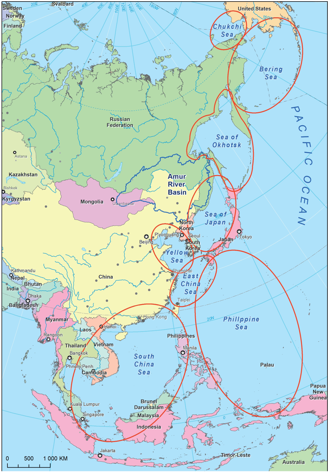
Fig. 1. The transboundary regions of East Asia
The specific features of East Asia include great differences and the contrasts of its particular territories and regions if considered from different perspectives. So, from the environmental standpoint, the macro-region houses virtually all natural zones of the Earth: from the ice Arctic deserts of North Siberia and Chukotka to the tropical forests of Indonesia. The macro-region is characterized by the most diverse combinations of the natural resources of the land and adjoining seas and oceans. In East Asia, the unique diversity of civilizations and cultures was formed including the unique Chinese, Korean, Japanese, and paleo-Asiatic ones, as well as the Russian northern indigenous nations represented by the Yakuts, Chukchi, Koryaks. Finally, in the countries of East Asia, the strong diverse political systems have emerged: presidential republics (Russia, Republic of Korea etc.), constitutional monarchies (Japan, Thailand), the countries of socialist orientation (China, Vietnam), and DPRK, a country with the communist political regime).
The differences in the levels of the social and economic development in East Asian countries are also considerable. Highly-developed countries (i.e. Japan, Singapore and Republic of Korea), dynamically developing ones (i.e. China, Malaysia, Vietnam and Russia) and less-developed states (i.e. Thailand, Laos, Myanmar, Indonesia and Philippines) are found side by side.
The critical characteristic unifying the countries and the regions of East Asia derives from their transboundary nature. Thus, a great part of the Russian Far East and Northeast China are included into the transboundary basins of the Chukchi, Bering, Okhotsk, Japan, and Yellow seas. In addition, there are several transboundary river basins in the East-Asia region including the Amur, the Ussuri, and the Tumen. The basins of the East China, South China, as well as the Philippine seas are also transboundary. According to our estimates, the transboundary regions of East Asia include practically 100% of its territory. Therefore, the transboundary phenomenon is the most important factor for East Asia combining its regions and countries into one integrated transboundary space.
The environmental, social-economic, cultural, and political characteristics of the macro-region combine to form a pattern that is diverse and unique. The dynamics of the separate parts and structures of this space are determined in many respects by the effect of the geographical and geopolitical factors. These factors also have different impacts on the long-term development of the countries and regions of East Asia. Such separate factors create the favorable prerequisites for the regional development, while the others restrict them. As a whole, the combined impact of the geographical and geopolitical factors and their spatial differentiation on the long-term development of the East Asia macro-region has not been practically investigated. Some works were devoted to Northeast Asia (Baklanov 2000; Geopolitical potential 2010; Larin 2016; Nature management 2005; Tkachenko 2009; Womarck Brantly 2014), the Far- Eastern region of Russia (Baklanov et al. 2016; Baklanov et al. 2015; Larin 2016), Northeast China, Vietnam (Baklanov et al. 2017; Larin 2014; Nature management 2005), the countries of Southeast Asia (Asia-Pacific 2010; Baklanov et al. 2017; Pacific Russia 2017). However, the transboundary nature of the macro-region presents additional complexity to understanding its long-term development. Therefore, the task of this paper is to make an aggregated assessment of the geographical and geopolitical factors and their role in the long-term development of the macro-region.
The geographical factors exerting a significant influence on the long-term development of the macro-region include their geographical and economic-geographical positions, the effect of the natural-climatic conditions due to their spatial differentiation, as well as a natural-resource potential in the form of the territorial and aqua-territorial combinations of natural resources.
The most important characteristic of the geographical position of East Asia resides in the fact that its greater part is a zone of the global contact among geographical structures (Baklanov 2000). Firstly, this is a junction between Northeast of Eurasia and the Pacific and Arctic Oceans resulting in different interrelations between land and the sea in the natural-ecological, natural-resource and economical spheres. Secondly, this is the place where Russia borders the world's largest economies (the USA, China and Japan). The contact structures serve as the basis for performing various functions, including utilization of different natural marine resources supported by inshore infrastructure in combination with terrestrial resources. The proximity and dynamic development of the countries of the macro-region generate the external-economic interactions through the joint partnership of land-based and marine transport systems, which in turn contribute to the extension of the market spaces.
The southern portions of the Russian Far East, the southeast portions of China as well as the areas of Vietnam, Singapore and Malaysia have the most favorable economic- geographical position from the viewpoint of interfacing with the external transportation routes and proximity to the developing markets.
Due to a variety of natural conditions, the most favorable opportunities for sustainable development are found in the southern areas of the Russian Far East and East China. Low temperatures, permafrost and other extreme conditions become the limiting factors in the central and northern portions of the Russian Far East. In the areas of East IndoChina, the tropical extreme natural processes, such as typhoons, floods and tsunami are frequent, although many of these regions are most favorable for cultivation of rice. Local populations have generally adapted to these natural- climatic disturbances (Baklanov et al. 2017).
For some areas of East Asia and adjacent seas, one can identify both land-based and aqua-terrestrial resources. Their similarity and differences for different areas, as well as their generalized natural-resource potential were estimated. The regions of the Russian Far East, Northeast China, Malaysia, Indonesia and Myanmar hold the highest potential. As a whole, one can note the great complementarity of land- based natural resources with marine natural resources, as well as some complementarity of natural resources in certain neighboring areas, like between the Russian Far East, Northeast China, Japan, Republic of Korea and DPRK (Nature management 2005; Tkachenko 2009). Such complementarity of land-based natural resources with those of the marine origin, as well as natural resources between neighboring countries, which is typical in the regions and countries of East Asia, create favorable conditions for the long-term sustainable development.
It should be noted that the regional contrasts within the transboundary space are generally large. Here, one finds neighboring countries vastly differing both by their size and development level (Table 1). The world's largest countries are China (18.7% of global GDP in 2018), Japan (4.1%) and Russia (3.1%). Smaller countries include Indonesia (2.6%), Republic of Korea (1.6%), Malaysia (0.74%), while Singapore is a small but highly-developed country.
Table 1. Grouping of the East Eurasia countries and regions according to their economic potential and growth rate (according to data for 2018)
Groups of countries by GDP volumes | Names of countries | GDP by IMF estimate at PPP, billion $ | Place occupied by country in the IMF list by GDP (of 192) | Growth of GDP (PPP) in the period of 1990 to 2018 by WB data (%) |
|---|---|---|---|---|
| 1. China | 25,270 | 1 | 2162 |
| including its eastern parts | 14,361 |
|
|
| 2. Japan | 5,594 | 4 | 127 |
1. Large | 3. Russia | 4,213 | 6 | 236 |
| including Pacific Russia | 46.7 |
|
|
| 4.Indonesia | 3,495 | 7 | 542 |
| 5.Republic of Korea | 2,136 | 14 | 489 |
| 6. Thailand | 1,320 | 19 | 441 |
| 7. Taiwan | 1,251 | 22 |
|
| 8. Malaysia | 999 | 26 | 709 |
2. Medium | 9. Philippines | 953 | 28 | 491 |
| 10. Vietnam | 710 | 34 | 1005 |
| 11. Singapore | 566 | 37 | 728 |
| 12. Myanmar | 344 | 52 | 1727 |
| 13 DPRK | 66.7 |
|
|
3. Small | 14. Cambodia | 70.5 |
|
|
15. Laos | 53.7 |
| 1013 | |
| 16. East Timor | 6.8 |
|
|
Compiled by: (fincan.ru 2019).
As the Table shows, from 1990 to 2018, many countries of East Eurasia have demonstrated extremely high rates of development: China has increased its GDP by 2,162%, Myanmar by 1,727%, Laos by 1,013%, Vietnam by 1,005%, Malaysia by 709%, Indonesia by 542% and Philippines by 491%. This is in contrast to many other regions of the world, where increases in the GDP have been lower. For example, the GDP during this same period has increased in the EU by 227%, the USA by 244%, Russia by 236%, and for the world taken together - by 370% (gtmarket.ru 2019; fincan.ru 2019). Among the geopolitical factors essential in the longterm development of the macro-region, we consider the geopolitical position of East Asia as a whole and its separate regions, as well as its transboundary phenomenon to be an important specific characteristic of the geopolitical position of the macro-region.
The essential features of the geopolitical position of this macro-region are determined by Russia and China, the eastern areas of which belong directly to East Asia. Russia and China have different "weights” and political systems but, in recent years, the strategic partnership was established between them.
The crucial component of the geopolitical position of the macro-region is the proximate neighborhood with the USA and strategic partnership between the USA, Japan and Republic of Korea that enhances geopolitical contrasts. The USA is one of the three largest countries by its geopolitical potential in the world (15.2% of the global GDP). It neighbors Russia and East Asia across the Bering Strait. The essential specific geopolitical role is performed by Japan. Being territorially a part of East Asia, this country has the closest and large economic and military-political ties with the USA. In this "team” Japan can be simultaneously considered an external geopolitical factor in East Asia. Its vicinity to the countries of Oceania and Australia, varying by political systems, is also of great geopolitical importance for East Asia.
In Eastern Asia, significant differences between countries and regions are reflected in their geopolitical potential (Table 2). On the one hand, China, Russia, and the USA are the largest countries of the world in terms of their geopolitical potential; and to perhaps a similar extent so is Japan and the Republic of Korea. However, there are a number of countries that have medium and small potential values.
Table 2. Main characteristics reflecting the elements of the geopolitical potentials of the countries and regions of East Asia (according data for 2017)
Regions | Area, thou. km2 | Share of transboundary territories in total area, in % | Length of coastline, km | Population size, thou. people | GDP, billion US$ |
|---|---|---|---|---|---|
1 Pacific Russia | 3,086.3 | 100 | 59,883 | 5,219 | 46.8 |
2 Eastern areas of China | 2,207.3 | 100 | 30,017 | 770,327 | 14,61 |
3 Japan | 377.8 | 100 | 29,020 | 126,824 | 5,443 |
4 DPRK | 120.5 | 100 | 4,009 | 28,491 | 66.7 |
5 Republic of Korea | 100.2 | 100 | 12,478 | 53,733 | 2,035 |
6 Taiwan | 36.0 | 100 | 2,007 | 24,827 | 1,189 |
7 Singapore | 0.78 | 100 | 268 | 5,470 | 528 |
8 Thailand | 514.0 | 100 | 7,066 | 71,037 | 1,236 |
9 Laos | 236.8 | 100 | 0 | 7,007 | 49.2 |
10 Cambodia | 181.0 | 100 | 1,127 | 24,827 | 64.3 |
11 Vietnam | 329.6 | 100 | 11,409 | 93,402 | 649 |
12 Philippines | 299.8 | 100 | 33,900 | 107,143 | 877 |
13. Malaysia | 329.8 | 100 | 9,323 | 41,700 | 993 |
14. Myanmar | 679.5 | 100 | 1,930 | 54,045 | 344 |
15. Indonesia | 1,904.5 | 100 | 95,181 | 269,479 | 3,250 |
16. East Timor | 14.9 | 100 | 706 | 1,212 | 6.8 |
In all | 10,418.8 |
| 298,324 | 1,684,743 | 31,138.8 |
Average value for country, region | 651.2 | 100 | 18,645 | 105,296 | 1,946.2 |
Compiled by: (www.wri.org 2019; gtmarket.ru 2019; fincan.ru 2019; InfoTables.ru 2019; gtmarket.ru 2019; Pacific Russia 2017).
Even greater contrast is reflected by the relative characteristics of the development of the territories including those which belong to the transboundary regions (Table 3). On the one hand, these estimates reflect a cumulative effect of the geographical factors on the development of the territories and, on the other hand, they reflect, perhaps to a larger extent, their geopolitical stability.
Table 3. Contrast of East Asia transboundary space according to the level of development (according to data 2018)
Names of countries | Population size, people/ km2 | Economic density, thous. US$ /km2 | GDP per capita, US$/person | Comparison to the country with maximum density (times) * |
|---|---|---|---|---|
1. China | 139 | 2,633 | 18,110 | 53 / 276 |
including its eastern parts | 349 | 6,506 | 18,643 | 21/ 112 |
2. Japan | 336 | 14,805 | 44,227 | 22 / 49 |
3. Russia | 8.6 | 246 | 29,267 | 859 / 2,957 |
including Pacific Russia | 12 | 48 | 9,817 | 6,157 / 15,218 |
4.Indonesia | 127 | 1,835 | 13,230 | 58 / 396 |
5.Republic of Korea | 494 | 21,315 | 41,351 | 15 / 34 |
6.Thailand | 131 | 2,568 | 19,476 | 56 / 283 |
7.Taiwan | 650 | 34,565 | 53,023 | 11 / 21 |
8.Malaysia | 86 | 3,030 | 30,860 | 86 / 240 |
9.Philippines | 333 | 3,179 | 8,936 | 22 / 229 |
10.Vietnam | 272 | 2,154 | 7,511 | 27 / 338 |
11. Singapore | 7389 | 727,506 | 100,345 | 1 / 1 |
12. DPRK | 189 | 556 | 2,341 | 39 / 1,308 |
13. Myanmar | 79 | 507 | 6,511 | 94 / 1,434 |
14.Cambodia | 80 | 389 | 4,335 | 92 / 1,868 |
15.Laos | 27 | 227 | 7,925 | 273 / 3,208 |
16.East Timor | 77 | 447 | 5,242 | 96 / 1,627 |
Compiled by: (gtmarket.ru 2019; fincan.ru 2019; InfoTables.ru 2019;gtmarket.ru 2019). In the numerator - differences in population density, in the denominator - in economic density.
Generally, taking into consideration a transboundary phenomenon, the sea water area crossed by national frontiers, and the portions mainland of the territories adjacent to it to some extent become the influence zones of neighboring countries and the zones of intersection of their mutual geopolitical interests. The estimates of the natural-resource potential owned by one country (in the coastal areas and marine exclusive economic zone) and, especially, stability and efficiency of the national types of resource management in the neighboring countries become interrelated and interdependent. This refers to all transboundary regions. According to our research (Baklanov et al. 2008; Baklanov et al. 2015; Geopolitical potential 2010), a transboundary phenomenon creates both favorable and negative conditions for the long-term development. So, when reaching the high standards of natural resource management in a neighboring country, the space and efficiency of the renewable resources regeneration (fish, forest, land etc.) are extended.
Under otherwise equal conditions, the integrity of the transboundary geosystems (including the marine ecosystem) creates objective opportunities for the longterm international cooperation of the countries within the transboundary region. This contributes to the rise of a sustainable natural resources management system, extension of the market space, and, as a result, long-term viable development of the region. At the same time, a risk of transboundary transfer of technogenic pollutants from one country to another, regular violations of the natural resources management standards in one of the countries, and lack of the sufficient information can impair the achievement of sustainable development in the transboundary region as a whole. All of the above-mentioned points are of great relevance for the countries and groups of countries included in various transboundary regions of East Asia.
Depending on how many countries border a transboundary sea (river), one can carry out specific zoning programs. This will determine a overlapping of influence zones and geopolitical interests of two, three or more countries within one transboundary region. Thereupon, we have identified the following types of the transboundary regions in East Asia: two-link regions facing the Chukchi, Okhotsk and Bering Seas; three-link zones facing the Yellow Sea; four-link territories (including the Amur transboundary region) facing the Sea of Japan; continent-island regions facing the East China and South China Seas and island regions facing the Philippine Sea. In the multilink transboundary regions, there is a concentration of national frontiers (land and maritime) of different countries which complicates their geopolitical relations in general (Baklanov 2000).
East Asia, mainly in its transboundary regions, is characterized by the presence of zones of international tension and geopolitical problems related to unresolved borders, some of which are remaining legacies of the World War II. In particular, there is a certain unsettledness with regard to differences in positions and related geopolitical tensions between DPRK and the Republic of Korea, between PRC and Taiwan, as well as a number of geopolitical problems associated with the ownership of individual Pacific islands (Table 4).
Table 4. Basic zones of geopolitical tension in the transboundary regions of East Asia
Names of transboundary regions | Subject and zones of the geopolitical tension | Parties (countries) where the geopolitical tension exists |
|---|---|---|
1. Chukchi Sea basin | Demarcation of the eastern part of the Arctic shelf | Russia - the USA |
2. Sea of Okhotsk basin | Claims of Japan to the South Kurile Islands | Russia - Japan |
3. Sea of Japan basin | Absence of peace treaties between countries Absence of official borders in the area of the Takeshima-Dokdo Islands | DPRK - Republic of Korea Japan - Republic of Korea |
4. East China Sea basin | Ownership of the Senkaku Archipelago (8 small islands with a total area of 7 km2) | Japan - Republic of China (Taiwan) - People's Republic of China (PRC) |
5. East China Sea basin | Ownership of Taiwan Island. Affiliation of Taiwan. China considers the island of Taiwan its territory. | China - Taiwan |
6. South China Sea basin | Ownership of the Spratly Islands (a key area in the context of regional presence and availability of oil and natural gas). | Vietnam - China- Taiwan - Malaysia- Philippines-Vietnam-Brunei |
7. South China Sea basin | Affiliation of the Paracel Islands | China - Vietnam |
8. Water area of the Sea of Japan | Naming of the sea (in the Republic of Korea and DPRK, this sea is called the Eastern Sea). | Republic of Korea, DPRK, Japan |
Compiled by: (www.geopolitics.com 2019).
The existence of such zones of tension in the transboundary regions creates significant constraints for sustainable natural resources management and development. The search for compromises and ratification of long-term international treaties are necessary.
Many countries and regions of East Asia have significant geographical (including natural-resource, advantages of location and collocation etc.) and geopolitical (transboundary phenomenon etc.) opportunities for longterm development.
Therefore, availability of considerable land-based natural resources and maritime natural resources seas is a favorable geographical factor for nearly all countries of the macroregion. Many of these resources are renewable (biological, forest, land, water, hydro-power, etc.) and thereby foster the long-term sustainable development of the macro-region.
At the current stage of development, this macro-region has the highest and steady rates of economic growth in the world. Eastern Asia is characterized by a very high contrast of the key socio-economic indicators of cross-border spaces of neighboring countries: population density, GDP values, and economic density. A steady decrease in the contrast among neighboring countries of Eastern Asia can be an important factor in reducing the level of conflict and the growth of sustainable development.
The most significant geographical limitations to its sustainable development are evident for the northern and northeastern portions of the Russian Far East, as well as the Western Pacific seismic arc. Within other countries, these limitations are less pronounced. Geopolitical tensions, such as territorial disputes, should be removed by diplomatic means, if all countries are to achieve sustainable international cooperation. In general, the transboundary phenomenon that is typical for all regions and countries ofEast Asia presents favorable opportunities for the long-term development.
The paper was prepared as part of the project No. 18-0504 under the "Far East” Program of the Far Eastern Branch of the Russian Academy of Sciences.
1. Asia-Pacific Economic Cooperation: yesterday, today, tomorrow. (2010). Vladivostok: the Far-Eastern Federal University. (in Russian).
2. Baklanov P.Y. and Moshkov A.V. (2015). Amur Region of Russia – natural resources, population and economy. In: Environmental Change and the Social Response in the Amur River Basin. Tokyo; Heidelberg; New York: Springer, 1-35.
3. Baklanov P.Ya. (2000). Contact geographical structures and their functions in the Northeast Asia. Proceedings of RAS, Series geogr., 1, 31-39. (in Russian).
4. Baklanov P.Ya. and Ganzei S.S. (2008). Transboundary territories: problems of the sustainable nature management. Vladivostok: Dalnauka. (in Russian with English summary).
5. Baklanov P.Ya., Moshkov A.V. and Romanov M.T. (2016). Pacific Russia: Basic factors and lines of the long-term development. Problems of geography, 141, 595-618. (in Russian with English summary).
6. Baklanov P.Ya., Yermoshin V.V., Karakin V.P., Zharikov V.V., Nguyen Van Qu, Dao Dinh Cham. (2017). Coastal-maritime nature management in the Pacific Russia and North Vietnam: concepts, structural features and types. Geography and natural resources, 4, 29-37. (in Russian with English summary).
7. Druzhinin A.G. (2016). Russian in the multipolar Eurasia: opinion of the geographer-social scientist. Rostov-on-Don: the Southern Federal University. (in Russian with English summary).
8. fincan.ru, (2019). GDP per capita PPP in 2018. [online] Available at: fincan.ru/articles/79_vvp-po-pps-na-dushu-naselenija-2018-stranmira/ [Accessed 27.09.2019].
9. Geopolitical potential of the transboundary cooperation of the Asiatic-Pacific region countries: joint monograph. (2010). Vladivostok: Dalnauka. (in Russian with English summary).
10. gtmarket.ru (2019). The ranking of the countries by their population. [online] Available at: gtmarket.ru/ratings/world-population/info/ [Accessed 27.09.2019].
11. gtmarket.ru, (2019). Ranking of the countries by their gross domestic product // The World Bank. [online] Available at: https://gtmarket.ru/ratings/rating-countries-gdp/rating-countries-gdp-info/ [Accessed 27.09.2019].
12. InfoTables.ru, (2019). The area of the countries of the world (table). [online] Available at: https://infotables,ru/strany-i-goroda/19-tablitsaploshchad-territoriy-stran-mira [Accessed 27.09.2019].
13. Kolosov V.A. (2018). Paradoxes of globalization and increasing barrier functions of the frontiers of the modern era. Regional studies, 3, 9-18. (in Russian with English summary).
14. Larin V.L. (2014). Realities of the new world and Russian-Chinese relations. In: Russia and China: experience and potential of the regional and near-border interaction. Vladivostok: Dalnauka, 9-19. (in Russian with English summary).
15. Larin V.L. (2016). Russian-Chinese trans-boundedness within the framework of the Eurasian integration projects. World economy and international relations, 12, 69-81. (in Russian with English summary).
16. Nature management of the Far East and Northeast Asia: potential of integration and sustainable development. (2005). Khabarovsk: FEBRAS. (in Russian).
17. Pacific Russia in the integrated space of the North Pacific in the early 21st century. Experience and potential of the regional and nearborder interaction. (2017). Vladivostok: IHAE FEBRAS. (in Russian with English summary).
18. Terada T. (2006). Forming an East Asian Community: A Site for Japan-China Power Struggles. Japanese Studies, 26(1), 1-13.
19. Tkachenko G. G. (2009). Territorial differentiation of the natural-resource potential of a group of countries in North-East Asia. Geography and Natural Resources, 30(2), 107-112. (in Russian with English summary).
20. Tulokhonov A.K. (2014). Political geography of North Asia under conditions of the globalization. Ulan-Ude: EKOS. (in Russian with English summary).
21. Womarck Brantly. (2014). Northeast Asia in a Multinodal World. East Asia, 31(3), 180.
22. www.geopolitics.com, (2019). All disputed territories of the world. Geopolicy. [online] Available at: www.geopolitics.ru/Karta-sajta/spisok-spornyx-territorij/ [Accessed 27.09.2019].
23. www.wri.org, (2019). List of the countries by their coastline // World Resources Institute. [online] Available at: www.wri.org/text/coastalmarine/variable-61.html [Accessed 27/09/2019].
Baklanov P.Ya., Romanov M.T. Transboundary regions of East Asia: geographical and political preconditions and limitations to long-term development. GEOGRAPHY, ENVIRONMENT, SUSTAINABILITY. 2020;13(1):57-63. https://doi.org/10.24057/2071-9388-2019-96

Editor-in-Chief
Kasimov Nikolay S.Lomonosov Moscow State University
Moscow 119991 Russia, Leninskie Gory, Faculty of Geography, 1806a
Phone +7 495 939-15-52
E-mail: ges-journal@geogr.msu.ru


